Annenberg Foundation
Reading Maps
Can you read a map? Scholars use an interactive technology tool to analyze maps of various kinds to gather evidence and data to better understand their meanings and usefulness. Using newly obtained knowledge, they form an interpretation...
Polar Trec
Playground Profiling—Topographic Profile Mapping
The Kuril islands stretch from Japan to Russia, and the ongoing dispute about their jurisdiction prevents many scientific research studies. Scholars learn to create a topographic profile of a specific area around their schools. Then they...
CK-12 Foundation
Topographic and Geologic Maps: Topographic Maps
Maps are great for helping you get where you're going, but what does that place actually look like? Geology scholars compare and contrast the features of topographical and geologic maps using an interactive lesson. The resource describes...
CK-12 Foundation
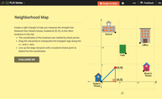
Pythagorean Theorem to Determine Distance: Neighborhood Map
Find the distance between various locations in a neighborhood. Scholars use the interactive to find distances between locations on a map. The map is overlaid onto a grid to provide coordinates for each location, and pupils apply...
Curated OER
Create Your Own Country Project
Young scholars demonstrate their knowledge of geography with this fun, collaborative social studies project. Working in small groups, students develop their very own countries, writing descriptions of their physical location, social...
Curated OER
Create a Country
Students work in small groups to list features and elements found on a variety of grade- appropriate maps. They develop a class list of map features and elements to draw from as they create a map of an imaginary country.
Curated OER
Mapping My World
First graders make two maps. In this developing and reading maps lesson plan, 1st graders read Mapping Penny's World, discuss the parts of a map, create a map of their classroom, and create a list of directions of how to get to various...
Curated OER
Mapping the Census
Students learn why the census makes a difference. For this U.S. Census lesson plan, students learn the key elements of cartography, examine the difference between data and their representation, and create a map using census data.
Curated OER
Transportation and Mapping
Students view murals that depict various modes of transportation. They discuss the importance of maps to navigation and create a map. They compare and contrast transportation of the past with modes of transportation used today.
Curated OER
Fantasy / Art Maps
Ninth graders analyze a fantasy art map by Jeremy Anderson, paying careful attention to the way the topographic features of the land are represented. They create a similar map of Sacramento that includes topographical features as well as...
Curated OER
Mapping Out the Story
Discuss the reading comprehension strategy of summarization with your elementary schoolers! They read a chapter from their social studies textbook, Regions Near and Far, and create a map, or word web, for the chapter. They identify...
Curated OER
Landscape Picture Map: Making a Map Grid
Students create a map grid system. In this map activity, students discuss how mapmakers use a grid system to make giving directions easier. Students learn how the grid system works and create a grid system on their landscape pictures.
Kate Stickley
Reading the World: Latitude and Longitude Lesson latitude and longitude, maps, coordinates on a map, prime meridian, reading maps, equator, globes
Find five activities all about longitude and latitude! Use oranges to show the equator and prime meridian, plot birthdays on a map using coordinates, and plan a dream vacation.
Curated OER
A Walk Around the School: Mapping Places Near and Far
After reading Pat Hutchins’ Rosie’s Walk, have your young cartographers create a map of Rosie’s walk. Then lead them on a walk around the school. When you return class members sequence the walk by making a list of how the class got from...
Luminations Media Group
Geography: Map Reading Basic Skills
Enhance scholars' map skills using this worksheet displaying the land of Kahitsa’an from the series, The Realm, by K.L. Glanville. The activity helps readers visualize the make believe-land, examine its attributes, and answer 10 short...
World Globes & Maps
United States Map- Intermediate Directions
Students identify the four intermediate directions. For this map skills lesson, students use post-it notes to label the four intermediate directions on a map. Students locate various states using intermediate directions.
Curated OER
Mapping Your State's Role in the Vietnam War
Learners recognize reasons to celebrate Memorial Day. Students create a map of victims of the VIetnam War. Using the internet, learners research information about soldiers from their state who were killd in action in Vietnam. Students...
Curated OER
A Visit to Hogwarts
Students collaborate in groups to read excerpts or entire selections from two Harry Potter books, use educational software to create concept maps detailing similarities and differences between first two Harry Potter books, and analyze...
Big History Project
Human Migration Patterns II
While humans have always been on the move, the period between 1400 and 1800 saw vast migrations of people between the East and the West. These migrations—whether through slavery or a desire to colonize new lands—shaped the modern world....
Curated OER
Maps and Globes
First graders complete a unit on map skills and the globe. They label maps, create a styrofoam ball globe, create a map of their community, sing a continent song, and complete a map and globe assessment worksheet.
Curated OER
Maps
Maps, globes, and computer software aid young explorers as they locate state capitols, major cities, geographic features, and attractions for states they are researching. They then use desktop publishing software to create a map to share...
Curated OER
Fairy Tale Maps
Students study direction as they listen to the stories of Little Red Riding Hood and The Jolly Postman. In this cardinal direction lesson, learners create a map to show the path Little Red Riding Hood took in the story and label the path...
Curated OER
Create A Map!
Students examine two- and three-dimensional shapes, and discuss map skills and attributes. They plan and create their own school campus maps using pre-cut building site shapes.
Curated OER
Pirate Map
Students write directions explaining how to get from one location to another by using a map of their town and use simple maps to identify and locate places.
Other popular searches
- Create a Map Rubric
- Create Map Keys
- Create a Map Interactive
- Graphing Create a Map
- Interpret and Create Maps
- Create a Map Worksheet
- Create a Map Interactivev
- Create a Map Key
- Create Map (Cut | Color)
- Student Create Maps
- Create Map of School
- Create a Map of a Country


