Curated OER
Mapmaker, Mapmaker, Make Me a Map
Second and third graders practice with basic map skills. They create their own map including a legend and a compass rose. This fabulous plan has many excellent websites linked which allow learners to explore maps of all kinds; including...
Annenberg Foundation
Reading Maps
Can you read a map? Scholars use an interactive technology tool to analyze maps of various kinds to gather evidence and data to better understand their meanings and usefulness. Using newly obtained knowledge, they form an interpretation...
CK-12 Foundation
Topographic and Geologic Maps: Topographic Maps
Maps are great for helping you get where you're going, but what does that place actually look like? Geology scholars compare and contrast the features of topographical and geologic maps using an interactive lesson. The resource describes...
Curated OER
Creating Mind maps
Students discuss their impressions of Africa. They work in groups to create a mind map. Students are explained what a mind map is. They discuss what they think are the defining features of the continent of Africa. Students create a giant...
Curated OER
Use Google Maps to Teach Math
Capture the engagement of young mathematicians with this upper-elementary math lesson on measuring time and distance. Using Google Maps, students first measure and compare the distance and time it takes to travel between different...
National Geographic
Mapping the Americas
Celebrate the geography of the Americas and develop map skills through a series of activities focused on the Western Hemisphere. Learners study everything from earthquakes and volcanoes of the Americas and the relationship...
PBS
Map a Model Solar System
Creating a solar system map is a snap thanks to a hands-on activity! Science scholars explore the solar system by building it wherever they choose during an interactive from PBS's Space series. Users pick both the location and scale for...
CK-12 Foundation
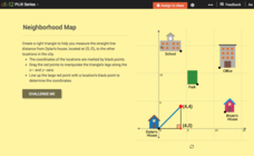
Pythagorean Theorem to Determine Distance: Neighborhood Map
Find the distance between various locations in a neighborhood. Scholars use the interactive to find distances between locations on a map. The map is overlaid onto a grid to provide coordinates for each location, and pupils apply...
Kate Stickley
Reading the World: Latitude and Longitude Lesson latitude and longitude, maps, coordinates on a map, prime meridian, reading maps, equator, globes
Find five activities all about longitude and latitude! Use oranges to show the equator and prime meridian, plot birthdays on a map using coordinates, and plan a dream vacation.
CK-12 Foundation
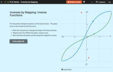
Inverses by Mapping: Inverse Functions
Map your way to successfully understanding inverse functions. Pupils use an interactive map to investigate how changes in the graph of a function affect the graph of its inverse. The results of the activity lead to the conclusion that...
CK-12 Foundation
Whole Number Multiplication: Multiplication Map
How many miles did a car travel if it traveled at 55mph for three hours? What are the factors for this multiplication sentence? These are the questions young mathematicians must solve using a multiplication map.
Friends of Fort McHenry
British Attacks in the Chesapeake during the War of 1812
This is a fun mapping activity that will have your class knowing the ins and outs of the battles in the War of 1812. Your young cartographers will not only plot decisive attacks, but will analyze their purpose, goals, and impact on...
Beauty and Joy of Computing
Sprite Drawing and Interaction
Discover how to program objects to move on a screen. In the second lab of a five-part unit, each learner uses block instructions to program a sprite to follow their mouse (cursor). They investigate how to use these same block...
Curated OER
Grid Frame Mapping
Students map and describe small area of the schoolyard and discuss habitats.
Concord Consortium
Understanding Probability Maps
What's the likelihood of your class understanding probability maps? Young scientists explore the concept using a virtual dartboard in an interesting simulation. The darts establish a pattern around the bull's-eye, which provides a visual...
Owl Teacher
Introduction to World of Geography Test
Assess your learners on the five themes of geography and the most important key terms and concepts from an introductory geography unit. Here you'll find an assessment with 15 fill-in-the-blank and 14 multiple-choice questions, sections...
Curated OER
Creating a Map
Third graders examine the process of creating an accurate map, and create a map of their playground. They identify what objects are on their playground, and discuss what is found on a map. Students then draw a map of their playground...
Curated OER
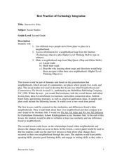
Interactive Atlas
Second graders examine the different ways people move from place to place in a neighborhood. Using the interactive online atlas MapQuest, they identify the various ways people move around their own neighborhood by creating a map and...
Curated OER
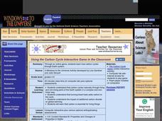
Using the Carbon Cycle Interactive Game in the Classroom
An online reading and interactive game bring the path of a carbon molecule to life for your earth science explorers! As an assessment, learners can map out or write about their experience in the carbon cycle. Thoroughly written...
Curated OER
Handy Map
Students become familiar with the purpose of maps through a hand mapping lesson. In this hand mapping lesson, students draw their hand and use it to explain directions and labeling on a map.
Curated OER
Mystery Map
Students compare and contrast varying approaches to present information, as they create a workable study guide. They create a Mystery Map with hidden words, facts, or hints to find treasures. Afterward, they interact and discuss...
Curated OER
Maps, Maps, and More Maps
First graders create a map and display an understanding of the cardinal directions. In this map skills lesson, 1st graders listen to stories where a map would come in handy, create their own map, and use the cardinal directions accurately.
Curated OER
Mapping the News
Students explore cartography. In this map skills and map making lesson, Students work in groups to create wall size world maps including legends, compass roses, latitude and longitude, and physical features. Students collect...
Curated OER
Story Mapping A Favorite Book
First graders create a diagram of a story by using the computer program Kidspiration. In this diagramming lesson plan, 1st graders will pick a book to write about. They then will plug in story elements of the book into the computer...


