Curated OER
Pirate Map
Students write directions explaining how to get from one location to another by using a map of their town and use simple maps to identify and locate places.
Nebraska Department of Education
Goal Maps
High school freshmen are asked to think about their future goals and reflect on what they have learned about the barriers they may face and the resources they have to overcome these barriers. Individuals then respond to questions on a...
Perkins School for the Blind
Beginning Map Skills
Maps can be so much fun, they help you understand spatial relationships, distance between objects, and can foster direction skills. Budding cartographers with visual impairments use the Wheatley Tactile Diagramming Kit to create their...
Edgate
Why Map a Map?
After brainstorming reasons why Native Americans mapped their lands, your young critical thinkers will work together to review their ideas and determine the definition of a map. With today's extensive use of mapping technology and GPS...
Royal Geographical Society
An Introduction to Maps
First graders are introduced to a variety of maps such as globes, street maps, atlases, and different types of floor plans. The focus of the lesson plan requires individuals to create their own plan of the classroom using the PowerPoint...
PBS
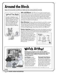
Around the Block
Arthur and his friends help children explore the concepts of family, community, and diversity in a fun series of activities. From performing peer interviews to mapping out the different places students have lived or visited, this...
Curated OER
Designing and Creating Earth Science Lessons with Google Earth
Everything from adding an overlay to uploading images to navigating the software, teachers become apt at using Google Earth™ in the classroom to create Earth Science lessons.
Mary Pope Osborne, Classroom Adventures Program
The Backpack Travel Journals
Strap on those backpacks, it's time to travel through history with this literature unit based on the first four books of The Magic Tree House series. While reading through these fun stories, children create story maps, record interesting...
Curated OER
Making Maps
First graders create a map of their classroom that can be used to find a hidden treasure. They examine two- and three-dimensional objects and discover characteristics.
Curated OER
Creating a Map
Third graders examine the process of creating an accurate map, and create a map of their playground. They identify what objects are on their playground, and discuss what is found on a map. Students then draw a map of their playground...
Curated OER
Map Skills
Students explore geography by creating a poster presentation in class. In this mapping lesson, students identify the different components featured on a modern day map and how to utilize them in order to navigate. Students read a book...
Curated OER
Put Your Face on the Map
Young scholars investigate topography and contour lines by examining a human face. In this mapping lesson, students create a plaster cast of a face and create a map of the contours of the face one centimeter at a time. Young scholars...
Curated OER
French and Indian War: Make A Map
Fifth graders create a map of the battles that occurred during The French and Indian War. In this history lesson plan, 5th graders read about the war in their text books, then divide into groups to create a detailed map of a famous...
Curated OER
Geography Awareness Week: Practice Mapping Skills
You won't get lost, after learning map skills during Geography Awareness Week.
Illustrative Mathematics
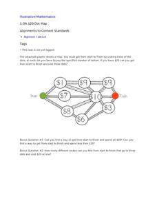
$20 Dot Map
Challenge the addition skills of young learners with this open-ended math problem. The task is simple, get from start to finish by connecting a series of three numbers. The trick is that the sum of the numbers must be less than or equal...
CK-12 Foundation
Whole Number Multiplication: Multiplication Map
How many miles did a car travel if it traveled at 55mph for three hours? What are the factors for this multiplication sentence? These are the questions young mathematicians must solve using a multiplication map.
Curated OER
Using the Carbon Cycle Interactive Game in the Classroom
An online reading and interactive game bring the path of a carbon molecule to life for your earth science explorers! As an assessment, learners can map out or write about their experience in the carbon cycle. Thoroughly written...
Curated OER
Create Learning Experiences with The Polar Express
Center content-integrated lessons around the timeless holiday book, The Polar Express.
Curated OER
Map Making/Floor Plans/Map Reading
Learners apply their knowledge of scale when mapping the classroom. They determine the use of a map legend and orient a map using a compass. They create the classroom maps using transfer graph paper.
NET Foundation for Television
1850-1874 Homestead Act Signed: The Challenges of The Plains
Start a whole new life in a land known as the Wild Wild West! Learners analyze maps, personal accounts, the Kansas-Nebraska Act, songs, and video clips to uncover life under the Homestead Act. Using their new skills, class members role...
Curated OER
MAPPING YOUR NEIGHBORHOOD
Learners uses atlases, maps, and Web resources to generate and examine maps of their own neighborhoods. This activity serve as background for the map-reading tasks in the next lessons.
Curated OER
Map It!
Fourth graders demonstrate map making skills by using the computer to create maps of the geographic features, regions, and economy for their state.
Curated OER
Mapping the News
Students explore cartography. For this map skills and map making lesson, Students work in groups to create wall size world maps including legends, compass roses, latitude and longitude, and physical features. Students collect current...
Curated OER
North Carolina Salt Dough Map Social Studies Project
In this lesson plan, North Carolina Salt Dough Map, 4th graders create a salt dough map of North Carolina, Students use dough to form the shape of the state of North Carolina. Students label the three regions of North Carolina and all...


