Curated OER
Biodiversity Memory Match Up
Learners are introduced to the animals of Asia. In this biodiversity lesson, students use interactive maps to identify animals from Asia, then play a memory game to reinforce the information.
Curated OER
What's Down There?
Students analyze data on coral reefs and use this to help characterize reefs. In this mapping coral reefs lesson students identify and explain the major threats to coral reefs.
Curated OER
Where in the World Is ...?
Students move themselves around a "world" map on the classroom floor, using lines of latitude and longitude to locate specific spots. They determine the locations of 11 countries where Peace Corps Volunteers are serving and identify in...
Curated OER
North, South, East, and West
A basic lesson on the teaching of the cardinal directions awaits your class. They are directed to go to different parts of the playground and where they attempt to describe their location in relation to each other by using the cardinal...
Bowland
You Reckon?
Sometimes simple is just better. A set of activities teaches young mathematicians about using plausible estimation to solve problems. They break problems down to simpler problems, use rounding and estimation strategies, and consider...
Curated OER
Monument Museum
Students design monuments, taking into account what is known about geometric shapes and measuring. Students create a museum complete with monuments and descritions of the monuments. Students provide guides at each monument in order to...
Curated OER
It's Happening, Where? Find the Absolute and Relative Location of News Articles
Students read newspaper articles. In this social studies lesson, students locate the latitude and longitude of the location where the news article takes place. Students write a summary of the news article.
Curated OER
Longitude & Latitude
Seventh graders role play as ship's captains to study longitude and latitude.
Curated OER
Plotting Amish Farmland
Second graders listen to the book, Down Buttermilk Lane by Barbara Mitchell. They discover how to read a grid and then together as a class, plot 2 squares, one yellow and one green. Then they plot the remaining squares independently and...
Curated OER
ExplorA-Pond:3rd Grade Probability
Third graders cut a map of a pond into grid squares. They count the total number of squares and calculate the probability of drawing a pond piece vs. a shoreline piece. They draw 10 pieces and compare the results with the original...
Curated OER
Tailoring Two Cultures to Adapt to Wisconsin's Biotic Zones
Middle schoolers examine the effect of the various ice ages on Wisconsin. In groups, they create a map representing the five geographic regions of Wisconsin. They must write out a description of each region to be placed on a poster...
Curated OER
From Home to School, GPS Style
Students are introduced and increase proficiency in the use of the hand held GPS system. They explore the meaning of longitude and latitude lines, then identify the parts of the map.
Curated OER
Where Can I See The Sea?
Students see how the pieces of the fossil puzzle fit together to allow the paleontologist to imagine the earth as it was millions of years ago. They draw a map showing what environments were present in a certain area more than 70 million...
Curated OER
May We Present Planet Earth?
Learners draw a map to scale. They illustrate knowledge of how to use DOGS TAILS on a map. Students identify the main parts of a map. They identify and illustrate the major features necessary for sustaining a quality of life for a society.
Curated OER
Lost Roman Treasure
Young scholars simulate what it would be like to be archeologists. They evaluate a quadrant area of a lost Roman treasure map. They generate their findings on the map into specific categorizes.
Curated OER
Research Question - Greenhouse Gas Emissions
Students review information from concept map to identify possible causes of greenhouse gas emissions, choose factor that they feel is largest contributor to greenhouse gas emissions in their town, and write research question on topic.
Curated OER
Powering a Green Earth
Students compare and contrast renewable and nonrenewable energy. For this environmental science lesson, students discuss the importance of going green. They identify the different components in a power grid system.
Curated OER
Discovering the Past Using the Future: Remote Sensing and the Lost City of Ubar
Young scholars use a video, maps, worksheets and Internet research to explore the role that sensing played in locating Ubar - the lost city of Arabia.
Curated OER
American Robin: A Robin's Menu Through the Seasons
Students read the article, A Robin's Menu Through the Seasons, taking notes and underlining key words and phrases. They create a math grid from the reading, research the animals in the article, and develop various writing assignments.
Curated OER
Great Questions for Tic Tac Toe
Fourth graders plan their own activities to reinforce the concepts being taught in school. The tic-tac-toe grid is used to help students create innovative learning activities to generate ideas.
Mathematics Assessment Project
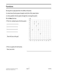
Functions
After identifying which of the given coordinate points fall on the graph of a line and which fall on the graph of a parabola, pupils write equations for each function.
Mathematics Assessment Project
Aaron's Designs
Learners first create designs for greeting cards by applying transformations of shapes on a coordinate plane, and then determine a sequence of transformations that produces a given design.
Curated OER
Proofs of the Pythagorean Theorem
Working individually and collaboratively, geometers gain a clear understanding of the Pythagorean theorem. They create, explain, and compare proofs of the theorem. Proofs involve areas of trapezoids, squares, and triangles, congruent...
Other popular searches
- Grid Map Skills Worksheets
- Grid Map Activities
- Second Grade Grid Maps
- Grid Map Skills
- Reading a Grid Map
- Grid Map Washington d.c.
- Letter Number Grid Maps
- Mapping Grid Maps
- Interpreting a Grid Map
- Letter/number Grid Maps
- Grid Map Lessons
- Grid Map Washington Dc

