Curated OER
Satellites and the Radiation Budget
Students engage in a prelab discussion about the earth's radiation budget and global warming. They use "trading cards" to find specific websites to research radiation budget questions.
Curated OER
Reading Satellite Images
Learners analyze satellite images. In this astronomy lesson, students examine 3 satellite images in order to understand how satellite images are taken and what they can teach scientists.
NASA
Down to Earth
There are only 10 types of people in the world: those who understand binary and those who don't. The lesson includes four activities in which students learn binary, convert binary to images, understand CCD arrays, and interpret...
Lawrence Hall of Science
DIY Sun Science
Get an up-close-and personal look at the sun from the safety of your classroom with this fun science application. Offering numerous activities, images, and videos, the resource supports children of all ages as they learn about the sun.
Curated OER
Message in a Bottle - A Satellite Journey through the Gulf Stream
The Gulf Stream has historically provided humans with a faster trade route because of its swift-moving waters. It continues to be a source of information and fascination for oceanographers today. As your class views this collection of...
Curated OER
Satellite Sense
Students look at data to understand how it is interpreted by scientists. In this satellite sense lesson, students complete worksheets based on radar and satellite images. Students work in groups of two to diagram a landform.
Curated OER
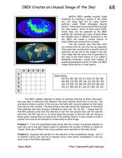
IBEX Creates an Unusual Image of the Sky!
In this IBEX satellite worksheet, learners read about the Energetic Neutral Atoms that are detected by the IBEX satellite. Students use a given hypothetical data string to determine the number of particles detected and create an 'image'...
Curated OER
Keep In Touch: Communications and Satellites
Fourth graders explore communications by reading assigned space science text. In this satellite instructional activity, 4th graders identify the concept of orbiting and examine gravitational pull by viewing diagrams. Students are...
Curated OER
LRO's First Image of Mare Nubium
In this scale image worksheet, students use an image taken by the LRO satellite of Mare Nubium to determine the scale of the image, the diameter of the smallest crater and a comparison scale drawing of a house.
NASA
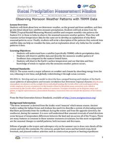
Observing Monsoon Weather Patterns with TRMM Data
Follow a fabulous slide show on how monsoons form and how satellite technology is being used to observe the phenomena, explaining why they occur. Afterward, visit the TRMM (Tropical Rainfall Measuring Mission) website to access actual...
Curated OER
What Color is the Ocean?
Students view satellite pictures of the ocean, and discuss the presence of phytoplankton and the colors of the ocean. Students compare/contrast ocean satellite images with maps and globes, then color world maps to replicate the satellite...
Curated OER
Sea Ice and Satellites
Students study satellites and satellite images using Google Earth. In this satellite lesson, students discuss satellites and how they work. Students watch a demonstration of how satellites work and learn what they are used for. Students...
Curated OER
Using Vegetation, Precipitation, and Surface Temperature to Study Climate Zones
Using NASA's Live Access Server, earth scientists compare the temperature, precipitation, and normalized difference vegetation index for four different locations. They use the data to identify the climate zone of each location using...
Curated OER
Interpreting Satellite Images
Young scholars identify differences between photography and satellite imagery space.
Curated OER
Super-Fast Solar Flares!
In this solar flares worksheet, students observe a sequence of figures of a solar flare observed in 2003 from the Ramaty High Energy Solar Spectroscopic Imager satellite. Students solve 6 problems including finding the scale of each...
Curated OER
Texture - Bumpy, Wrinkled, Smooth?
Students study textures and identify textures using satellite images. In this texture lesson, students study various objects and define their textures. Students feel crayon rubbings and sort them into groups. Students use a book with...
Curated OER
Satellite Images- Night Time
Fourth graders study the geography and population distribution of various places on earth. They utilize actual satellite images of the night sky (lights showing heavily around area of dense population) to study and make observations...
Curated OER
Get the Picture!
Astronomers practice downloading data from a high-energy satellite and translate the data into colored or shaded pixels. As a hands-on activity, they use pennies to simulate high-energy satellite data and they convert their penny...
Curated OER
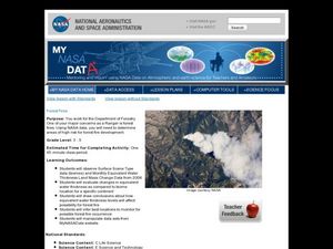
Forest Fires
Students play the role of a Ranger with the Department of Forestry. In this forest fires lesson, students examine data on biomes and images to determine high risk areas for forest fires to develop.
Curated OER
Remote Sensing - What Can We See When We Can't Touch?
Students discover how remote sensing is used to identify the signatures of life even when the particular life form is not directly observable. They investigate how a satellite "sees" objects on the surface of Earth.
Curated OER
Our Eye in the Sky: The TIROS Weather Satellite
Young scholars investigate the political context of the creation of a weather satellite. In this technology and society lesson, students explore the historical, technological, and political context of the TIROS weather satellite. They...
Curated OER
Geography from Space
Students explore geography as seen from space. In this web-based lesson, students brush up on geography skills by identifying geographic locations based on satellite or aerial images and a brief clue.
Curated OER
The Hinode Satellite Views the Sun
In this sun's magnetic field lines worksheet, students use a photograph taken by the Hinode Satellite that shows the complex magnetic structure of the sun over a sunspot. Student predict the magnetic field lines and draw them on a...


