Curated OER
China: Dim Sum: 3 Mapping Lessons
Fourth graders, after studying maps, draw a very large outline map of Asia and then a large map of China on it in the appropriate place. They label the appropriate information.
Curated OER
Crazy Crazy Bones
Students practice labeling the bones of a human skeleton. Students reword the song "Dry Bones" with the accurate names of the bones listed.
Curated OER
Hunting for Hidden Fat
Students investigate the importance of fat in the diet. They determine the difference between solid and liquid fat. They examine food labels to identify the ones that contain fat.
Curated OER
Consumer Power
Students examine the labels on their own clothes to determine where they were made and think about important factors when shopping for different items. They figure how much the person who makes their sneakers would get and complete a...
Curated OER
The Seasons
Students label posters with the four seasons of the year. They draw or use magazine pictures that demonstrate the clothing worn for each season. They brainstorm a list of holidays that occur within each season.
Curated OER
Trade Route By Sea To Asia
Eighth graders study a map and identify the countries of Spain, Portugal, India, China and Thailand. After a class discussion, 8th graders explain the advantages of trading over land and by sea and they explore the men who journeyed to...
Curated OER
Build a Burger
Students read about hamburgers and analyze a healthy diet as well as the importance of nutrition. In this nutrition education lesson, students read the background information about hamburgers and their nutrition facts. Students complete...
Curated OER
Map of Austria
In this geography of Austria instructional activity, students color and label a map with major cities and important physical features. Neighboring countries are also shown but are not labeled.
Curated OER
Australia Map Resource Sheet
In this Australia map resource worksheet, students use the map of Australia to supplement their study of the country. They see a map labeled with Australian cities, and the surrounding countries and water bodies.
Curated OER
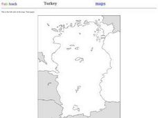
Outline Map of Turkey
In this outline map of Turkey worksheet, students see a blank map of the country with the adjoining countries shaded in gray. There are no labels on the map.
Curated OER
Outline Map of Guam
In this outline map of Guam worksheet, student see a black line map of the country with the capitol city of Agana labeled on it. There are no questions to accompany the map.
Curated OER
Former Soviet Map Quiz
For this outline map quiz worksheet, students examine the provided map and label the noted countries that used to be part of the former Soviet Union.
Curated OER
Where in the World Do Those Cookies Come From?
Students discuss exports and imports by discovering where the ingredients come from for making chocolate chip cookies. They take a survey of their favorite cookies and create a bar graph to represent the information.
Curated OER
United States Map
Students compare the United States on a globe and on a map. In this map lesson, students relate the sizes of the continents and locate the United States. Students identify the location of the continental US as well as Alaska and Hawaii.
Curated OER
Wages, Earning Power, Profit, and Responsibility: International Lessons
Students participate in an interactive activity to determine where their clothers were made. They examine the lives of children from Latin America who harvest crops in the fields or manufacture apparel in factories.
Curated OER
North American Biomes
In this Science worksheet, students color a biome map of North America. Students color the map by solving the clues listed on a separate sheet of paper.
Curated OER
Operation Iraqi Democracy
In this lesson, students consider various forms of government and examine the idea of political sovereignty, then prepare outlines for oral presentations on international models of government. For homework, they write response papers...
Curated OER
Social Studies: Church and State
Discuss the separation of church and state as it relates to government entities. This is a great way to launch a discussion on the relationship between these groups. Learners analyze this relationship in governments throughout the world,...
Foreign Policy Association
U.S. and Europe Online Lesson Plan
Class groups investigate the economic and political implications of a country's policies on genetically modified foods, craft a position paper detailing that policy, and share their findings with the class. Armed with this...
Curated OER
China Quest
Read and research information on China. Young researchers complete a knowledge hunt about China then locate and describe each location using directional words. They recognize the word meaning through context clues and application practice.
Curated OER
Cyberspace Safari
Middle schoolers go on an information gathering hunt on the Internet to study West African empires. They work in teams; meteorologists, bankers, writers, and archaeologists. They collect data on all sorts of topics related to West...
Curated OER
Arbor Day in the Classroom
Creating an environmentally-aware classroom can be exciting and educational at the same time.
Curated OER
Be a Food Detective
Students explore how food is made and what are healthy and unhealthy eating habits. They participate in activities to further show them foods nutritional value.
Math Worksheets Land
Pie or Circle Graphs Problems - Independent Practice Worksheet
Third graders take a set of data and turn it into a pie graph with an independent worksheet. Containing 10 sets of data, the resource reinforced data analysis skills that pupils can use throughout a graphing unit.
