Owl Teacher
Introduction to World of Geography Test
Assess your learners on the five themes of geography and the most important key terms and concepts from an introductory geography unit. Here you'll find an assessment with 15 fill-in-the-blank and 14 multiple-choice questions, sections...
Random House
Mapping Skills
Spark interest and enhance your pupils' map skills using Matteo Pericoli's book, See the City: the Journey of Manhattan Unfurled. Through Pericoli's illustrations and text, learners explore the East and West...
Curated OER
Deserts of the World
The major deserts of the world are labeled on this geography worksheet. An excellent map of the world showing where the deserts are located, is used along with a list of the 12 major deserts of the world. Very good!
Alpha Omega
History and Geography—Two World Wars
Here's a combination textbook/workbook that examines the conditions in Europe that lead to World War I. Ideal for homeschoolers as well as classroom use.
Luminations Media Group
Geography: Map Reading Basic Skills
Enhance scholars' map skills using this worksheet displaying the land of Kahitsa’an from the series, The Realm, by K.L. Glanville. The activity helps readers visualize the make believe-land, examine its attributes, and answer...
Oregon State
World Map of Plate Boundaries
Young geologists piece together the puzzle of plate tectonics in an earth science lesson. Given a physical map of the world, they search for land formations that indicate the location of different types of plate boundaries.
Richmond Community Schools
Map Skills
Young geographers will need to use a variety of map skills to complete the tasks required on this worksheet. Examples of activities include using references to label a map of Mexico, identify Canadian territories and European...
Curriculum Corner
Holidays Around the World
Let's focus on a holiday from around the world! Young researchers choose a holiday from somewhere around the world, and conduct research to answer questions about the holiday. It can be used anytime during the year!
PBS
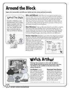
Around the Block
Arthur and his friends help children explore the concepts of family, community, and diversity in a fun series of activities. From performing peer interviews to mapping out the different places students have lived or visited, this...
Curated OER
State Map of Utah
In this social studies worksheet, students examine a state map of Utah and answer 7 questions, using the map as a reference. The map includes freeways and bodies of water. There is no compass rose.
Curated OER
Read a Map
In this word problem worksheet, 5th graders use a coordinate grid as a map to answer 6 problems. They work with ordered pairs, locate quadrants, and apply the information to find items in the zoo.
Curated OER
Map of Africa
Using a completed map (not provided), pupils will use this map to fill in the geographic features of Africa. An appropriate map can be printed using the Internet and placed under a document camera for the class to reference.
Curated OER
War of 1812: Map and Label
Map test! Hand out this map of the East Coast of the United States and let learners mark each of the nine sites listed. They'll be making a map that shows the battle sites and areas involved in the War of 1812. Great as a test or as a...
Curated OER
The Netherlands: map
Use the provided list to label a map of Europe and the Netherlands. There are 77 locations to label. You have to know your stuff to fill out this challenging map.
Curated OER
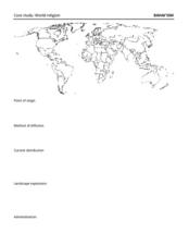
Map: Bahai'ism
How much do you learners know about the Bahai religion? If this is a topic of study in your class, they'll be able to use the provided map to show the diffusion, location, origin, and distribution of this not-so-well-known sect that...
Curated OER
World Map Labels
In this geography skills worksheet, students identify the countries and bodies of water labelled on the maps of the world, Africa, Asia, Canada, Europe, the Caribbean, the Middle East, North America, Australia, and South America.
Scholastic
The Seven Wonders of the Ancient World
The Colossus of Rhodes, the Hanging Gardens of Babylon, the Lighthouse of Alexandria. Young archeologists investigate the Seven Wonders of the Ancient World, map their locations, and match their names with brief descriptions and images....
Curated OER
World Geography - Climate Notes
A challenging activity helps young geographers explore the temperatures around the world! They study how the Earth's land temperatures are affected by their proximity to an ocean, as well their latitude and their altitude. A very...
Curated OER
Chapter 6: Christianity and the Transformation of the Roman World
The history of the Christian faith makes up a fascinating element of western civilization, as demonstrated in this comprehensive online resource. A chapter quiz features short-answer questions based on the ministry of Jesus, the spread...
Curated OER
Map Quiz 1
In this map quiz 1 worksheet, students answer questions relating to geography, not interactively, then scroll down to see the answers.
Curated OER
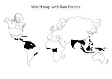
World Map With Rain Forests
In this geography worksheet, students study a map of the world which shows shaded areas indicating where the rain forests are located. There are no labels for countries or continents.
Curated OER
Eastern European Studies
One worksheet, three projects. Learners explore Eastern Europe and mark Eastern European countries on a map. They then collect and record census data on thirteen different countries, and write a 3-5 page expository essay on one of the...
Curated OER
Mt. Whitney to Death Valley
This is an intriguing problem that brings together real-world data, technology, and mathematical problem solving. If visibility wasn't an issue, could you see from the highest point in the lower 48 states, Mt. Whitney, to the lowest...
Curated OER
Ancient Egypt Geography
Nine questions to answer and one map to read. Seventh graders will use the map of Ancient Egypt to practice map reading skills and build a visual image of Ancient Geography.
Other popular searches
- World War Ii Map
- World War I Map
- World War 2 Map
- World War I Outline Map
- World Climate Map
- World Biomes Map
- World Outline Map
- Blank Map of the World
- World Political Map
- Ancient World Greece Map
- World Time Zone Map
- Deciduous Forests Map World


