Curated OER
Planning a Trip from Vancouver BC
Students plan a weekend car trip to Seattle Washington. They leave Friday afternoon and arrive back Sunday afternoon.
Curated OER
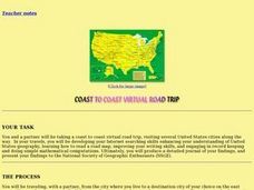
Coast to Coast Virtual Trip
Young scholars complete a variety of exercises and activities as they plan a coast to coast trip across America. They keep a journal that includes where they went, what they did, what they saw, etc. They compare two cities they visited...
Curated OER
Scale Drawings
Students discuss the importance of scaling drawings. In this math lesson, students create a scaled drawing of circuit boards. They explain why accuracy is very important when scaling.
Curated OER
What Is That Bubblin¿¿¿ In My Back Yard?
Students create a map plotting local sites the Environmental Protection Agency has on its EPA Regulated Sites list. They discuss the need for citizens to, at a minimum, be aware of potential pollution hazards in their community.
Curated OER
Our Little Town
Students draw a map of their local community using a drawing program. Using the internet, they locate various landmarks and identify famous people living or coming from their town. They participate in interviews with the community...
Curated OER
Mapping the Border
Students create maps of the borderland region. They decorate their maps with colors, pictures, icons, scenes, words that reflect their understanding of the character and history of the borderland.
Curated OER
What Is That Bubblin' In My Back Yard?
Students are introduced to the GIS system. They create a map plotting local sites the Environmental Protection Agency has on its EPA Regulated Sites list. They identify a list of schools that are near potentially hazard sites.
Curated OER
How Long Will It Take To Get There?
Fourth graders estimate the average traveling distance to a city of choice with the help of an internet site. They determine the amount of time it will take to travel there at a speed of 65 miles per hour. Students set up a proportion to...
Other
Mapquest
Find website allows you to get step-by-step walking or driving directions to your destination and to avoid traffic with optimized routes. It will also give you information about hotels, food, gas, shopping, etc. along the route or nearby.
Houghton Mifflin Harcourt
Holt, Rinehart and Winston: World Atlas: Philippines
This map of the Philippines from MapQuest is a clear map labeling the cities, islands, and physical features. There is also a chart of some quick facts about the country.
Houghton Mifflin Harcourt
Holt, Rinehart and Winston: World Atlas: Argentine Republic
Find all the basic data on Argentina on this page. Contains a clear map from "MapQuest", flag and facts in a list format. Categories include languages, religions, life expectancy, currency, GDP, industry, agriculture and more.
Houghton Mifflin Harcourt
Holt, Rinehart and Winston: World Atlas: Chile
Find all the basic data on Chile on this page. Contains a clear map from "MapQuest", flag and facts in a list format. Categories include languages, religions, life expectancy, currency, GDP, industry, agriculture and more.
Houghton Mifflin Harcourt
Holt, Rinehart and Winston: World Atlas: Ecuador
Find all the basic data on Ecuador on this page. Contains a clear map from "MapQuest", flag and facts in a list format. Categories include languages, religions, life expectancy, currency, GDP, industry, agriculture and more.
Houghton Mifflin Harcourt
Holt, Rinehart and Winston: World Atlas: Bolivia
Find all the basic data on Bolivia on this page. Contains a clear map from "MapQuest", flag and facts in a list format. Categories include languages, religions, life expectancy, currency, GDP, industry, agriculture and more.
Houghton Mifflin Harcourt
Holt, Rinehart and Winston: World Atlas: Bangladesh
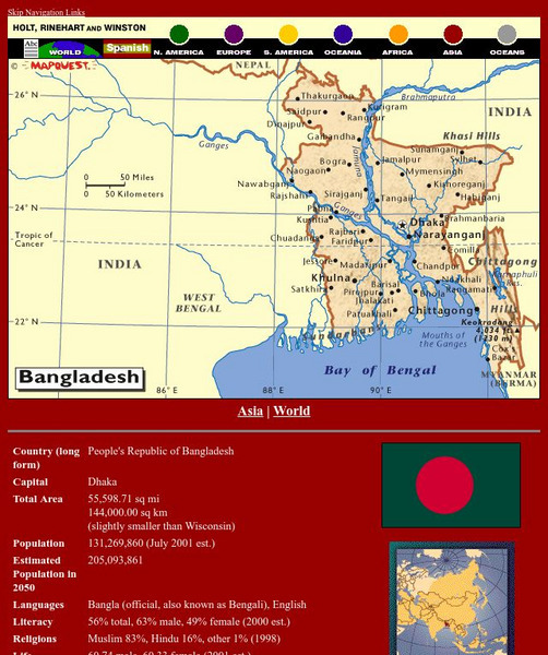
Find all the basic data on Bangladesh on this page. Contains a clear map from "MapQuest", flag and facts in a list format. Categories include languages, religions, life expectancy, currency, GDP, industry, agriculture and more.
Houghton Mifflin Harcourt
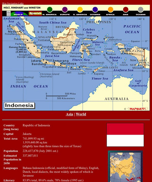
Holt, Rinehart and Winston: World Atlas: Indonesia
Find all the basic data on Indonesia on this page. Contains a clear map from "MapQuest", flag and facts in a list format. Categories include languages, religions, life expectancy, currency, GDP, industry, agriculture and more.
Houghton Mifflin Harcourt
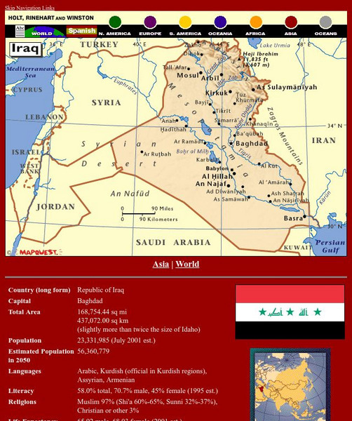
Holt, Rinehart and Winston: World Atlas: Iraq
Find all the basic data on Iraq on this page. Contains a clear map from "MapQuest", flag and facts in a list format. Categories include languages, religions, life expectancy, currency, GDP, industry, agriculture and more.
Houghton Mifflin Harcourt
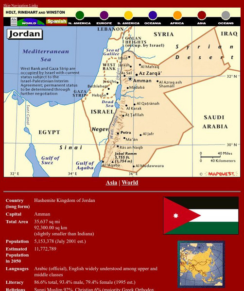
Holt, Rinehart and Winston: World Atlas: Jordan
Find all the basic data on Jordan on this page. Contains a clear map from "MapQuest", flag and facts in a list format. Categories include languages, religions, life expectancy, currency, GDP, industry, agriculture and more.
Houghton Mifflin Harcourt
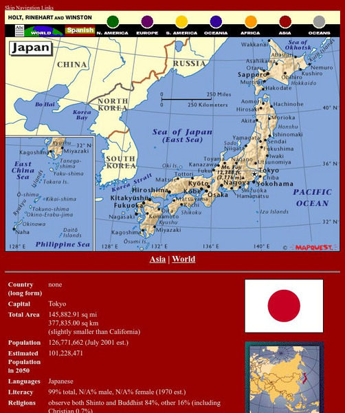
Holt, Rinehart and Winston: World Atlas: Japan
Find all the basic data on Japan on this page. Contains a clear map from "MapQuest", flag and facts in a list format. Categories include languages, religions, life expectancy, currency, GDP, industry, agriculture and more.
Houghton Mifflin Harcourt
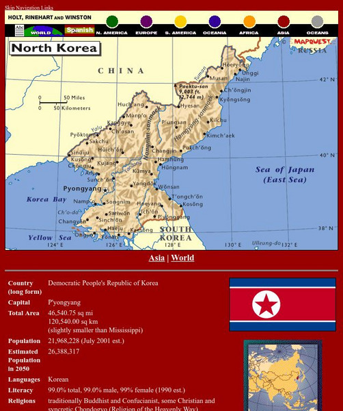
Holt, Rinehart and Winston: World Atlas: North Korea
Find all the basic data on North Korea on this page. Contains a clear map from "MapQuest", flag and facts in a list format. Categories include languages, religions, life expectancy, currency, GDP, industry, agriculture and more.
Houghton Mifflin Harcourt
Holt, Rinehart and Winston: World Atlas: Peru
Find all the basic data on Peru on this page. Contains a clear map from "MapQuest", flag and facts in a list format. Categories include languages, religions, life expectancy, currency, GDP, industry, agriculture and more.
Houghton Mifflin Harcourt
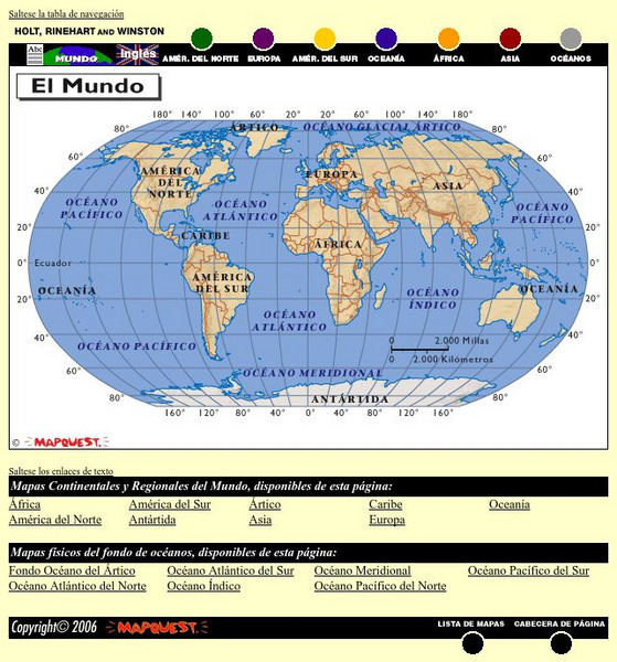
Holt, Rinehart and Winston: El Mundo
This is an online resource in Spanish to the countries of the world, detailed maps of these countries from Mapquest, their flags, and statistical data. Statistical data includes literacy rates, industry, agriculture and natural...
Houghton Mifflin Harcourt
Holt, Rinehart and Winston: World Atlas: Iran
Find all the basic data on Iran on this page. Contains a clear map from "MapQuest", flag and facts in a list format. Categories include languages, religions, life expectancy, currency, GDP, industry, agriculture and more.
Houghton Mifflin Harcourt
Holt, Rinehart and Winston: World Atlas: Israel
Find all the basic data on Israel on this page. Contains a clear map from "MapQuest", flag and facts in a list format. Categories include languages, religions, life expectancy, currency, GDP, industry, agriculture and more.
