Curated OER
California Outline Map
In this California outline map worksheet, students examine political boundaries of the state and the placement its capital city as well as its major cities. This map is not labeled.
Curated OER
West Virginia Map
In this map activities worksheet, learners use an outline of the map of West Virginia to add the state capital, major cities, and other state attractions. Students complete 3 activities.
Curated OER
Arkansas Map
In this Arkansas worksheet, students analyze an outline map of the state of Arkansas and label the capital city. Students label other important cities and important attractions and color the map.
Curated OER
North Dakota Map
In this North Dakota instructional activity, students study an outline map of North Dakota with the capital city marked. Students color the map and add other important cities and landmarks.
Curated OER
Utah Map
For this Utah worksheet, students analyze an outline map of the state of Utah. The capital city is marked. Students add other important cities, bodies of water or other important features. Students color the map.
Curated OER
Maryland Map
In this Maryland worksheet, students analyze an outline map of the state of Maryland. Students fill in the state capital, major cities and other state attractions.
Curated OER
Idaho Map
In this outline state map of Idaho worksheet, students fill in the map with the state capital, major cities, and other state attractions or teacher created directions. Students draw at least 7 answers.
Scholastic
Organization Outline
Forming a strong organizational outline is important when reading a complex text, writing an informative essay, or analyzing a complicated problem. Use a straightforward organization outline to teach learners about concept mapping.
Curated OER
Romania
In this blank outline map learning exercise, students explore the political boundaries Romania located in Europe. This map may be used in a variety of classroom activities.
Curated OER
North Carolina Salt Dough Map Social Studies Project
In this lesson plan, North Carolina Salt Dough Map, 4th graders create a salt dough map of North Carolina, Students use dough to form the shape of the state of North Carolina. Students label the three regions of North Carolina and all...
Curated OER
Outline Map of Japan
In this geography worksheet, students examine a black line outline map of Japan. There is a compass rose on the page. There are no labeled cities.
Curated OER
Map Keys
In this geography worksheet, students identify who a cartographer is and what they do specifically. They study an outline map of a fictitious island and then, respond to the three questions that follow. Finally, students add three more...
Curated OER
Food on the Map
Students work together to examine the tastiest towns in the United States. After discovering the names of the equipment, they identify the seven continents. They take a survey and locate the cities and states of the foods mentioned.
Curated OER
Comprehension: Identify Story Grammar
This fully scripted lesson could be a big help for someone new to teaching Kindergarten. It outlines what you should do and say as you teach grammar and literary elements such as, main character, setting, and events through reading. The...
Curated OER
Using Social Studies in Five Shared Reading Lessons: Geography
After several short 15-minute mini-lessons, your learners will gain an understanding of the characteristics of a non-fiction text. Using the book Map It by Elspeth Leacock, your class will become acquainted with non-fiction terms such as...
Rainforest Alliance
Knowing the Essential Elements of a Habitat
To gain insight into the many different types of habitats, individuals must first get to know their own. Here, scholars explore their school environment, draw a map, compare and contrast their surroundings to larger ones. They then write...
Curated OER
Indiana State Map
In this Indiana state map worksheet, students color and label the important cities and physical features on this outline map. Students also learn of Indiana's location in the U.S. by studying the background map.
Curated OER
Blank Map: The United States of America
In this map worksheet, students use the blank outline map of the United States to label the 50 states or for any other study purpose. Each state boundary is shown with no name labels.
Curated OER
Rhode Island Map
For this recognizing the shape of the state of Rhode Island worksheet, students fill in the state capital, major cities, and other attractions or follow their teacher made directions. Students write at least 7 answers.
Curated OER
Weather Maps
Students interpret information on a weather map in order to construct a graph, and discuss how the weather impacts their lives.
Curated OER
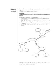
Semantic Mapping
Students explore semantic mapping. Through teacher modeling and independent practice they complete a variety of semantic (concept) maps to coincide with specific areas of subject matter. They identify the core concept and include...
Curated OER
Ollie the Own Says: WHO
Scholars examine the strategy of making a story map or outline to identify the main elements of a story. They discuss the who, what, where, when, why, and how of a story, in an outline form. As a class they read a short story, answer the...
Curated OER
You Are Here
Students map local places and learn to use scale and distance. In this mapping lesson, students map their school and a favorite place. Students recreate their maps showing distance and scale sizes. Students locate their location on a...
Southern Nevada Regional Professional Development Program
Using Maps to Inspire Personal Narratives
A solid description of one way to teach narrative writing, this resource outlines the writing process from concept to completion. Class members create concept maps of moments in their lives and follow the writing process to publish their...


