Curated OER
Geography of South America
Young explorers study South American geography. They study maps and create a physical map of the Andes themselves! They also research the geography, environment, and the culture of the Andes and present a report to the class.
Curated OER
Mapping South America
Middle schoolers explore South America. In this South American lesson, students use their geography skills to create population, terrain, biomes/vegetation, and major exports maps. Middle schoolers present their finished maps to their...
Curated OER
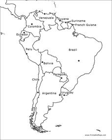
South America Outline Map
For this outline map worksheet, students discover and investigate the physical boundaries of the countries in South America. The names of countries and a star to mark the capital city are included.
Curated OER
South America Outline Map
In this outline map worksheet, students discover and investigate the continent of South America. No country borders or physical features are depicted. This blank outline map may be used for a variety of classroom activities.
Curated OER
South America Layered
Seventh graders create an overlay map of South America. They show the relationships between population, landforms and economies with their maps.
Curated OER
South America: Physical Map
In this South American physical map worksheet, students make note of the major landforms and bodies of water located on the continent.
Curated OER
Welcome to the Americas
Students research and map the North and South American continents. In this geography lesson on the Americas, students can locate North, Central and South American countries and states. Students choose a location to research and prepare a...
National Geographic
Mapping the Americas
Celebrate the geography of the Americas and develop map skills through a series of activities focused on the Western Hemisphere. Learners study everything from earthquakes and volcanoes of the Americas and the relationship...
Curated OER
Americas: Physical Map
In this Americas physical map worksheet, students make note of the major landforms and bodies of water located on the North American and South American continents.
Curated OER
Rivers, Maps, and Math
Students use maps to locate and label the major rivers of North and South America. Using the internet, they identify forests, grasslands, mountain ranges and other landforms on the continents as well. They compare and contrast the...
University of Florida
Sailing to St. Augustine
Using a Florida map from 1597, young explorers consider the physical characteristics they would need in a site for a new colony and the resources they would need to survive. After selecting a site, class members research to discover the...
Curated OER
Landforms and Resource Regions
In this geographical regions worksheet, students read a short passage, examine 2 maps which show landforms and regions in South America, then answer 4 comprehension questions based on the information from the maps and the reading passage.
Curated OER
World Map and Globe - Lesson 15 (K-3)
Students discover mountain ranges and their locations in the world. In this physical map lesson, students locate and identify major mountain ranges of the world on a large physical map.
Curated OER
Political Legends and Map Symbols
Students identify the legend and map symbols. In this map skills lesson, students use a world map to find various locations using a map key.
Curated OER
The Exploration and Settlement of North America
Students locate place in Canada and explore highlights of early of early American exploration and settlement. In this North American history instructional activity, students locate provinces, major cities, and physical features...
Curated OER
The African Slave Trade: From West Africa to South Carolina and Beyond
Eighth graders explore the African slave trade. They identify the principal figures practicing the African slave trades at three locations. Students draw the physical routes of the slave trade on a map and they list the reasons for the...
Curated OER
World Map and Globe - Lesson 15 Mountains of the World
Students locate major world mountain ranges. In this geography lesson, students identify major mountain ranges on 6 on of the 7 continents on a large world physical map.
Curated OER
World Map Labels
In this geography skills worksheet, students identify the countries and bodies of water labelled on the maps of the world, Africa, Asia, Canada, Europe, the Caribbean, the Middle East, North America, Australia, and South America.
Curated OER
Directions, Directions
Third graders review cardinal directions, moving around the room so that they are standing in the part of the room that is nearest the north, south, east and west. They are asked what would you do if they are lost? Pupils work as a...
Curated OER
Maps that Teach
Students study maps to locate the states and capital on the US map. Students locate continents, major world physical features and historical monuments. Students locate the provinces and territories of Canada.
California Polytechnic State University
Australian Geography Unit
At the heart of this resource is a beautifully detailed PowerPoint presentation (provided in PDF form) on the overall physical geography of Australia, basic facts about the country, Aboriginal history, and Australia culture and lifestyle.
Curated OER
Natural History of Costa Rica
Students use outline maps to become acquainted with Costa Rica. They see how it was formed and how its origin has created very diverse environments. Students then use atlases and compare their physical maps with maps of climate and the...
Curated OER
The Roanoke Mystery
Fourth graders hypothesize about what happened on the island of Roanoke. In this South Carolina history lesson, 4th graders use primary documents to draw conclusions about what happened to the Lost Colony of Roanoke. This mini-unit...
Curated OER
When a Map Isn't A Map...
In this maps activity, students read about the Earth, sky, rivers and lakes, and more, and then answer short answer questions about it. Students complete 3 questions.


