Curated OER
Maps and Globes: Where in the World are We?
Students explore maps and globes. In this introduction to map and globe concepts lesson, students identify features of physical maps, political maps, and globes. Students locate land and water, and recite a poem about the names of the...
Curated OER
Water Features - Lesson 2 - U.S. Political Map Grade 4-5
Students locate water features on maps. In this geography lesson, students complete worksheets that require them to identify water features on a U. S. political map.
Curated OER
Maps
If your students are just starting a unit on Geography this could be the introduction you're looking for. This PowerPoint presents a clear and organized overview of the different types of maps people use and why each is important. Tip:...
Curated OER
U.S. Political Map
For this political map worksheet, students use the map of the United States and the 7 cities to measure the straight-line distance between the cities. Students add the total number of miles traveled and write their answers in the spaces.
Curated OER
Africa: Political Map
Young scholars create a political map for Africa. In this country identification lesson plan, students locate Africa on a globe and discuss some of its major countries and bodies of water. Young scholars complete a political...
Curated OER
Using a Political Map
In this online interactive map activity activity, students examine a political map of New Jersey and respond to 9 fill in the blank questions.
Curated OER
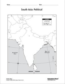
South Asia: Political Map
In this South Asia political map instructional activity, students examine the national boundaries. The map also highlights each country's capital city.
Curated OER
Mexico: Political Map
In this Mexico political map worksheet, students examine state boundaries. The map also highlights major cities in Mexico.
Curated OER
Mexico: Political Map
In this Mexico political map worksheet, students examine state boundaries. The map also highlights major cities in Mexico. This map is unlabeled.
Curated OER
Europe: Political Map
In this Europe political map learning exercise, students examine each country's boundaries. The map also highlights each of the nation's capitals with a star.
Curated OER
U.S. Political Map
Students explore the symbols found in a map legend. In this map skills lesson plan, students locate the legend on a political map and explain what each of the symbols mean. Students locate and identify several symbols on the map.
Curated OER
Asia and the South Pacific: Political Map
In this Asia and the South Pacific map worksheet, students examine national political boundaries and national capitals in this region of the world.
Curated OER
World: Political Map
For this world political outline map worksheet, students examine boundaries of each of the countries in the world. This map not is labeled.
Curated OER
World Political Map
In this blank outline map instructional activity, students note the political boundaries of the nations of the world on a Mercator projection map.
Curated OER
South Asia: Political Map
For this South Asia outline map worksheet, students & examine boundaries of each of the countries in the region. This map is labeled with the country and capital city names.
Curated OER
World Governments and Mapping Activity
Here you will find maps, great informational text, and vital information on political systems and government. The slide show provides material on democratic and nondemocratic systems of government as well as a map activity intended to...
Curated OER
Women in Texas Politics: Winning the Vote, Three Pioneers, and Serving the People
Fourth graders study women's involvement in Texas politics. In this US history lesson, 4th graders discuss woman suffrage, examine three Texas female pioneer legislators by reading biographies, and explore women's issues by generating a...
DocsTeach
Red Record of Lynching Map Analysis
Long before the civil rights movement, leaders were working to secure equal rights. An informative activity explains the 1922 anti-lynching campaign with a map. Scholars analyze the map, complete a worksheet, and participate in group...
Curated OER
Africa Political Map
In this blank outline map worksheet, students explore the political boundaries of the continent of Africa, the countries located there, and label other geographic features.
Curated OER
Southeast Asia and the South Pacific: Political
In this Southeast Asia and the South Pacific political map worksheet, students examine boundaries of each of the countries and the placement of the capital cities. The major bodies of water are labeled.
Curated OER
Europe Labeled Map
In this Europe political map worksheet, students examine the national boundaries. The map also highlights each of the nation's capitals with a star. The countries and capital cities in this map are labeled.
Curated OER
Canada Outline Map
In this Canada political map worksheet, students examine the province boundaries of the nation. The province names are labeled on the map.
Curated OER
European Country Map
In this Europe political map worksheet, students examine the national boundaries. The country names are labeled on the map.
Curated OER
South America Map
In this South America political map worksheet, students examine the country boundaries. The map also labels each of the countries and their capitals.
Other popular searches
- Wwi Political Map
- Maps of Europe Political
- Physical and Political Maps
- Canada Political Map
- Americas Political Map
- Blank Political Maps
- Political Map of Africa
- United Kingdom Political Map
- Europe Political Map
- Physical & Political Maps
- Mexico Political Map
- State Political Maps


