Beverly Hills High School
Mapping Napoleon's Empire at Its Height (1812)
The complicated political history of Europe becomes apparent as young historians create a map of the borders of France when Napoleon's Empire was a its height in 1812.
Curated OER
Western Civilizations, Chapter 23: Modern Industry and Mass Politics, 1870-1914
Looking for an interactive way to supplement your western civilization course? Check out this comprehensive website, designed to accompany the Western Civilizations text (although it is valuable independently). Scholars investigate...
Curated OER
Women in Texas Politics: Winning the Vote, Three Pioneers, and Serving the People
Fourth graders study women's involvement in Texas politics. In this US history lesson, 4th graders discuss woman suffrage, examine three Texas female pioneer legislators by reading biographies, and explore women's issues by generating a...
Curated OER
Politics and Religion in 17th Century Dutch Art
Seventh graders examine different pieces of Dutch Art. They identify its social and political meanings by using cultural and historical information. They examine maps of the time period as well.
National Endowment for the Humanities
A Defense of the Electoral College
Each presidential election year, the debate about the electoral college rages. Michael C. Maibach's "A Defense of the Electoral College" offers young political scientists an opportunity to examine a reasoned argument for why the...
Curated OER
Using Different Kinds of Maps
Third graders explore the landforms and population diversity. They read maps and examine geographic terms. Students create their own map of the United States and answer questions about the location of people. After exploring the map, 3rd...
Curated OER
Fossil Fuels (Part I), The Geology of Oil
Junior geologists work through three mini-lessons that familiarize them with the formation and location of fossil fuels. Part one involves reading about petroleum and where it comes from via a thorough set of handouts. A lab activity...
Curated OER
United States Map- State Capitals
Students explore map skills. In this state capital lesson, students view a United States Political Map and identify and use post-it notes to label the state capitals.
Curated OER
Map It!
Fourth graders demonstrate map making skills by using the computer to create maps of the geographic features, regions, and economy for their state.
Curated OER
United States Map- State Capitals
Students explore the state capitals. In this geography lesson plan, students use a political map to identify the state capitals and place post-it notes on various capitals.
Curated OER
Mapping the Census
Students learn why the census makes a difference. In this U.S. Census lesson plan, students learn the key elements of cartography, examine the difference between data and their representation, and create a map using census data.
Curated OER
Map Keys
Third graders examine maps and map keys. In this locating map features lesson plan, 3rd graders use crayons, markers and colored pencils to label maps. Students work in partners to read map keys and locate given places and things.
Curated OER
Understanding "The Stans"
Students explore and locate "The Stans" in Central Asia to create, write and illustrate maps, graphs and charts to organize geographic information. They analyze the historical and physical characteristics of Central Asia via graphic...
Curated OER
A world of oil
Learners practice in analyzing spatial data in maps and graphic presentations while studying the distribution of fossil fuel resources. They study, analyze, and map the distribution of fossil fuels on blank maps. Students discuss gas...
Curated OER
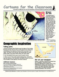
Cartoons for the Classroom: Geographic Inspiration
A wonderfully graphic cartoon entices learners to read more about issues near the Arabian Peninsula. They will use the provided cartoon and critical thinking question to practice building their analytical and critical thinking skills....
Curated OER
Western Civilizations, Chapter 9: The High Middle Ages: Religious and Intellectual Developments
If you are looking for a comprehensive guide to western civilizations, explore this online resource! Although designed for use with the Western Civilizations text, this site can be implemented in any course. A chapter quiz challenges...
Curated OER
Mapmaker, Mapmaker, Make Me a Map!
Students evaluate the different types of historical and geographical information that one can gather through close study of historical maps from the 16th through the 19th centuries. They create their own maps.
Curated OER
Waldseemuller's Map: World 1507
Students investigate the 1507 word map. In this world geography lesson, students examine the details of each section of the map and then draw conclusions about how the people of 1507 understood the world. Students are evalated on...
Constitutional Rights Foundation
Refugees From Vietnam and Cambodia
The United States may have pulled its troops from the Vietnam War in 1973, but the conflict was far from over for the citizens living in Asia at the time. An informative resource lets learners know about the wave of over 220,000...
Curated OER
Map Analysis Worksheet
In this map analysis worksheet, students decipher what type of map they are using based on a complete list of criteria. Students then answer multiple questions based on their discoveries.
Curated OER
Western Civilizations, Chapter 5: Roman Civilization
Investigate Ancient Rome with this comprehensive online western civilizations website. While designed for use alongside the Western Civilizations textbook, the tools on this site can be used to emphasize any study. A chapter quiz...
Curated OER
Map Reading in the 21st Century
Students interact with MapPoint tools to view maps of the past and the present in multiple ways. They participate in mini-lessons aimed at locating certain points of interest or famous routes taken in history.
Curated OER
Summertime Travel
Third graders write about a summer event they participated in. In this paragraph writing instructional activity, the teacher models how to write about a place they have visited. Students then write their own paragraphs. Students...
Curated OER
Map It!
Fourth graders collect and explore different maps and their uses before using the program Pixie to create maps of geographic features, political features, and economic information for the state in which they live.

