Curated OER
Taking a Trip Through the Regions
Students identify the location and characteristics of different regions throughout the world. Using this information, they compare and contrast the regions and discover how they change over time. They use the internet to research a place...
Curated OER
Map Me a Paragraph
There are so many great reading strategies. In this instructional activity, learners practice decoding. They break down two paragraphs to analyze and determine main ideas and details. They each observes ways to model as they map their...
Curated OER
Mapping Perceptions of China
Students discuss what types of things are included on a map. They compare and contrast maps of China with a map they create and practice using different types of maps. They write analysis of their classmates maps.
Curated OER
What Do Maps Show?: Lesson 1 Introduction to Maps
Learners brainstorm a list of the different types of maps they have seen or used. Using the activity sheet, they look through a social studies book to find all the maps and to determine what they are used for. Using a poster, they review...
Curated OER
Just Draw Me a Map!!!!
Middle schoolers draw a map to give directions to someone rather then give them too many relative locations.
Curated OER
Geographic Regions and Backyard Geology with the USGS Tapestry Map
A beautiful tapestry map of North America is examined by geology masters. The map incorporates the topography and geology of different regions. You can purchase printed copies or a large poster of the map, or if you have a computer lab...
Indian Land Tenure Foundation
Create a Map
Do your students have a connection to their natural environment? Create neighborhood maps together with your little learners. The instructional activity starts as the class talks about where they live and what their homes look like. They...
Museum of Science
Make a Map
It's important to know the final destination. Scholars first measure distances in a region of interest using a standard measuring device or by counting steps. They then use an appropriate scale and graph paper to create a map of the...
Owl Teacher
Introduction to World of Geography Test
Assess your learners on the five themes of geography and the most important key terms and concepts from an introductory geography unit. Here you'll find an assessment with 15 fill-in-the-blank and 14 multiple-choice questions, sections...
Curated OER
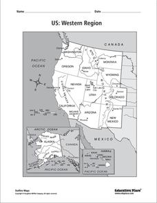
US: Western Region Map
For this United States Western Region worksheet, learners examine the state boundaries and landforms found in this region. The map also highlights each of the state capitals.
Curated OER
US: Northeast Region Map
In this United States political map worksheet, students examine the state boundaries of the Northeast Region. The map also highlights each of the state capitals denoted by stars.
Curated OER
US: Western Region Map
In this U. S. Western Region outline map worksheet, students examine boundaries of each of the states and the placement of the capital cities. This map is not labeled.
Curated OER
US: Midwest Region Map
In this U. S. outline map worksheet, students examine boundaries of the Midwest Region states and the placement of the capital cities. This map is labeled.
Curated OER
California: Landform Regions Map
In this California landforms map worksheet, students examine the landform regions located within the state of California.
Curated OER
Learning to Read a Regional Map
Students locate the local community, surrounding communities and major geographic features of the SE Utah and the Four-Corners region on a map, after receiving direct instruction.
Curated OER
We're on the Map!
Students identify a variety of topographic map symbols. They make generalizations about an unidentified community by reading and interpreting map symbols.
Curated OER
Learning About Maps
Learners take a "field trip" with the teacher through the school then draw a diagram of what they saw. They bring the maps to the computer lab where they create electronic maps using the software program Neighborhood Map Machine.
Curated OER
Map Quiz 1
In this map quiz 1 worksheet, students answer questions relating to geography, not interactively, then scroll down to see the answers.
Curated OER
A Comparison of Cloud Coverage Over Africa
Students use a NASA satellite data to contrast amounts of cloud coverage over different climate regions in Africa. They explore how Earth's major air circulations affect global weather patterns, and relate to local weather patterns.
Curated OER
Fossil Fuels (Part I), The Geology of Oil
Junior geologists work through three mini-lessons that familiarize them with the formation and location of fossil fuels. Part one involves reading about petroleum and where it comes from via a thorough set of handouts. A lab activity...
Curated OER
Nazi Concentration Camps -- Map and Chart-Reading Activities
Students use an informational chart about Nazi concentration and death camps to complete a mapping activity and a chart-reading activity.
Curated OER
Charting Neptune's Realm:
Students explore how to construct and interpret maps and globes and find information about people, places, regions, and environments.
Library of Congress
Investigating the Building Blocks of Our Community’s Past, Present, and Future
As Ken Jennings said, "There's just something hypnotic about maps." Certainly, the longer you look at them the more you can learn. In this project-based learning lesson, individuals study both historic and present-day maps of their area...
Curated OER
Regions of South Carolina
Third graders explore the 5 regions of South Carolina. In this regions lesson, 3rd graders locate the regions on a map and compare and contrast the areas. Students have sentence strips that have facts about the regions on them, students...


