Curated OER
Scale Skills
In this mapping skills activity, students read an excerpt that describes three different types of scales and how to calculate distance on a map. They respond to two short answer questions using the map provided on the sheet and to...
Curated OER
Problem-Solving Decisions: Reasonable Answers
In this problem solving worksheet, students answer 6 questions pertaining to a story problem about a tabletop scale model of the Nile River.
Curated OER
Battle of Clontarf 2
In this Battle of Clontarf worksheet, learners read about the battle, answer short answer questions, draw a picture, and estimate the population. Students complete 4 activities.
abcteach
Street Mapping
What's around the block? Or down the street? Ask your pupils to tap into their map skills by drafting the area around their home and school.
Curated OER
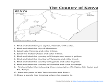
The Country of Kenya
In this map completion worksheet, students observe a map and map scale of Kenya to find and label bodies of water, cities, countries, and the equator. Students answer 11 questions.
Curated OER
Diagon Alley in Toronto
In this Harry Potter worksheet, students draw a diagram of Toronto's wizarding quarter. Students make the map as colorful and accurate as possible.
Curated OER
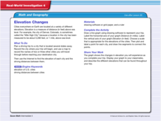
Real World Investigation- Math and Geography- Elevation Changes
For this math and geography real world investigation, 6th graders plan a driving trip to a city that is located several states away from their home while recording the elevations of three cities that are included in the trip. They use...
National Center for Case Study Teaching in Science
To Boldly Go, or Not
Here is a different way to combine social studies and science. Have your high schoolers read a passage about the 2004 vision for space exploration and then discuss the practicality, costs, and reasons for returning to the moon. Then, the...
Curated OER
The Life and Times of Guy Fawkes
In this Guy Fawkes instructional activity, students cut apart 8 sentence strips; each tells an event in the life of Guy Fawkes. Students put them in the right order, paste them on a paper, and illustrate each event.
Curated OER
Corridor of Time Fieldtrip Worksheet and Explorers Heritage Center History Hunt
For this Corridor of Time and Explorers Heritage Center worksheet, students respond to 29 short answer and fill in the blank questions regarding information presented in the North Dakota Heritage Center.
Curated OER
The Roman Empire-Map Activity
In this Roman Empire instructional activity, students complete a map activity in which they label and color civilizations, countries and physical features as instructed. There are no maps included.
Curated OER
Digging Into Science: Final Analysis
In this archeological excavation worksheet, learners complete 9 short answer questions based on a simulated archeological activity they performed in a small group.
Curated OER
Globe Skills Lesson 5
In this map skills learning exercise, students read a text selection about locations during the American Revolution and then respond to 8 fill in the blank questions.
Other popular searches
- Construct Scale Drawings
- Scale Drawings and Maps
- Creating Scale Drawings
- Scale Drawings and Models
- Scale Drawings Using Grids
- Life Size Scale Drawings
- Geometry Scale Drawings
- Flags Create Scale Drawings
- Scale Drawings Worksheet
- Bearings Scale Drawings
- Scale Drawings Aircraft
- Understand Scale Drawings


