Curated OER
The Weather in South America
Students conduct Internet research on weather and weather conditions in South America. They read a weather report in Spanish, and answer worksheet questions on South American countries and their weather conditions.
Curated OER
South American Outline Map
In this blank outline map instructional activity, students study the political boundaries of the continent of North America and those of the countries located there.
Curated OER
Countries of South America
Middle schoolers focus on the geography of the countries of South America. Using a map, they identify the European countries who claimed the South American countries and research the influences they had on South America. To end the...
Richmond Community Schools
Map Skills
Young geographers will need to use a variety of map skills to complete the tasks required on this worksheet. Examples of activities include using references to label a map of Mexico, identify Canadian territories and European...
Curated OER
Tour Of South America
Students explore South America. For this geography lesson, students research landmarks of historical or national significance and use their findings to create slideshows.
Curated OER
Geography of South America
Student's identify geographic features of a South American map. They use the scale of the map to calculate distances between points. They identify examples of the five geographic themes on the map of South America.
Curated OER
South America and Central America Capitals Map Quiz
In this online interactive geography quiz activity, students examine the map that includes all of Central and South America's countries. Students match each of the country names to the appropriate locations on the map.
Curated OER
South America and Central America Map Quiz
In this online interactive geography quiz worksheet, learners examine the map that includes all of Central and South America's countries. Students match each of the country names to the appropriate locations on the map.
Curated OER
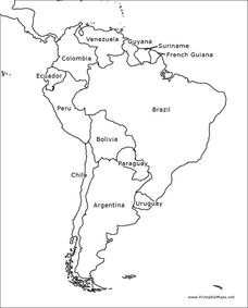
South America Outline Map
In this blank outline map worksheet, students explore the political boundaries of South America and the nations there. This map may be used in a variety of classroom activities. The map is labeled with the country names.
Curated OER
South Carolina Jeopardy
One of the better PowerPoints I've come across is a "Jeopardy"-style game whose focus is South Carolina. Some excellent photographs and maps make the slides especially good. The "Final Jeopardy" clue is especially challenging. An...
Curated OER
Mapping South America
Middle schoolers explore South America. In this South American lesson, students use their geography skills to create population, terrain, biomes/vegetation, and major exports maps. Middle schoolers present their finished maps to their...
Curated OER
Molas from South America
Third graders research world geography by creating a class presentation. In this South American lesson, 3rd graders read assigned text regarding the customs and traditions of different Indian communities in South America. Students...
Curated OER
Country: Brazil
Students use the internet to explore the culture, history, language and animals of Brazil. They read first hand accounts of students growing up in the South American country.
Curated OER
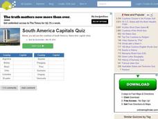
South American Capitals Quiz
In this online interactive geography quiz worksheet, students respond to 12 identification questions about the capital cities of South America. Students have 4 minutes to complete the quiz.
Curated OER
Video Boxes
Young scholars create a video box about a Central American country. In this world history lesson, student research Central America and pick a country they want to investigate. They work in groups to create a video box that shows images...
Curated OER
South America Map
In this South America political map worksheet, learners examine the country boundaries. The map also labels each of the countries and their capitals.
Curated OER
Welcome to the Americas
Students research and map the North and South American continents. In this geography lesson on the Americas, students can locate North, Central and South American countries and states. Students choose a location to research and prepare a...
Curated OER
Why War? Causes of the American Revolution and South Carolina's Role
Eighth graders investigate the role of South Carolina in the American Revolution. In this colonial American instructional activity, 8th graders analyze primary documents and images to determine how the state was involved in the outbreak...
Curated OER
Data Comparison And Interpretation: North Korea, South Korea, And the United States
Ninth graders brainstorm "what they know about North Korea and South Korea." They determine the approximate distance from the United States to North and South Korea and create a graph comparing the birth rates, death rates, infant...
Curated OER
Latin America Map Quiz
For this Latin America map quiz worksheet, students label all of countries on Central and South American shown on the blank outline map.
Curated OER
Bank Loans Money to Start Businesses
After locating Latin American countries on a world map, children read about how microbanks are loaning money to help start small businesses. Involving both current events and economics, the teacher introduces the article with a map...
Curated OER
Geography of South America
Students explore South America. In this geography skills lesson, students watch a video about the geographical features of the continent. Students complete worksheets on the topic.
Curated OER
South Carolina Responds
Students examine and explain the events that lead up to the Revolutionary War. In this Revolutionary War lesson, students summarize and evaluate several of the major battles that defined the Revolutionary War.and major battles involving...
Curated OER
Into the Wild: Settling the South Carolina Backcountry
Eighth graders select their own plot of land in the Backcountry to settle in the 1700s in SC. Students first find a point for settlement and sketch out the best route from the Lowcountry to arrive at the point. They...


