Curated OER
Creating Mind maps
Learners discuss their impressions of Africa. They work in groups to create a mind map. Students are explained what a mind map is. They discuss what they think are the defining features of the continent of Africa. Learners create a giant...
Curated OER
Mapping Where Animals Live
What type of reptiles live in New York State? This lesson gets the class thinking about what factors determine where particular animals live. They analyze the Hudson Valley environment, identify specific reptile and amphibian...
Curated OER
Mapping My Spot in History
Young scholars create their own town's history. They place themselves on the map in a literal as well as figurative sense. Students produce portions of an updated version of an early twentieth century panoramic map. Young scholars gather...
Curated OER
Africa: Introduction, Geography and Mapping
Students study the geography of Africa through the use of maps. They locate, distinguish, and describe the relationships among varying regional and global patterns of geographic phenomena such as landforms, climate, and natural resources.
Curated OER
Across the United States- Home Learning Activity
In this home-school United States map worksheet, students work with a family partner as they study a map of the United States. They talk about the states they have visited, play a game by giving each other clues about states, and write...
Curated OER
The French Revolution and Napoleon, 1789-1815
Here is an interesting and somewhat interactive presentation. Covering the French Revolution, the slide show begins with a timeline of Napoleon's rise to power and ultimate fall. Main ideas for each event are then outlined with critical...
Curated OER
Using Social Studies in Five Shared Reading Lessons: Geography
After several short 15-minute mini-lessons, your learners will gain an understanding of the characteristics of a non-fiction text. Using the book Map It by Elspeth Leacock, your class will become acquainted with non-fiction terms such as...
Curated OER
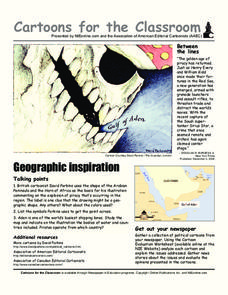
Cartoons for the Classroom: Geographic Inspiration
A wonderfully graphic cartoon entices learners to read more about issues near the Arabian Peninsula. They will use the provided cartoon and critical thinking question to practice building their analytical and critical thinking skills....
Curated OER
Food on the Map
Pupils work together to examine the tastiest towns in the United States. After discovering the names of the equipment, they identify the seven continents. They take a survey and locate the cities and states of the foods mentioned.
Curated OER
Waldseemuller's Map: World 1507
Students investigate the 1507 word map. In this world geography lesson, students examine the details of each section of the map and then draw conclusions about how the people of 1507 understood the world. Students are evalated on...
Curated OER
Local History: Mapping My Spot
Students explore maps to discover historical information about their local area. For this mapping and history lesson, students use panoramic maps of their own town/city to interpret historical information. Students also place...
Curated OER
Map the Civil War
Students explore the Civil War through original maps. In this mapping lesson, students calculate distance and show it on an original map. Students examine the type of landscape and its landmarks and draw symbols on the map.
Curated OER
United States Map
Students access prior knowledge and locate the North and South Poles on the map. In this mapping lesson, students understand the position of the United States relative to the poles. Students answer questions about the globe.
Curated OER
Map Analysis Worksheet
For this map analysis worksheet, students decipher what type of map they are using based on a complete list of criteria. Students then answer multiple questions based on their discoveries.
Curated OER
Map Memory
Fifth graders, working in a whole class setting, label a United States map with the names of all the states that they know. They transfer the names of the states to an individual map and color it. Next, they receive directions on how to...
Curated OER
Holocaust Map Studies
Middle schoolers analyze maps and answer discussion questions related to WWI. In this geography lesson, students analyze historic maps to determine causes and effects of WWI in Europe. Middle schoolers read testimonies of Holocaust...
Curated OER
Second Graders on the Map
Second graders explore the various types of maps. They examine the differences between street maps and aerial photographs. Students identify various features on each map. They use cardinal directions and the compass rose. They write...
Curated OER
As a Bird Flies or as a Submarine Dives...
In this geography learning exercise, students look critically at a map containing a variety of different directions. Students answer 2 short answer questions regarding giving someone the best directions from point A to point B.
Curated OER
Waldseemüller’s Map: World 1507
Students take a closer look at historical maps. In this primary source analysis lesson, students examine the first world map produced by Martin Waldseemuller. Students complete the included map analysis worksheet and then write letters...
Curated OER
But Where Is It On This Modern Map? A problem-solving, mind-boggling experience!
Trace Columbus' voyages by locating them on 21st Century maps. Using a navigators lesson, 4th graders will examine the Age of Exploration and trace Columbus's routes accurately on laminated world maps using different maps. Note: You...
Compton Unified School District
How Can We Locate Places?
How can we locate places? Maps, of course! Expose second graders to the tools available in maps and discuss how these tools can help people find locations. Students also look at communities, including what makes a community and the...
BrainPOP
Latitude and Longitude Differentiated Lesson Plan
Scholars warm-up their map skills with a discussion using location words to describe familiar places. An engaging video informs class members about latitude and longitude. Three leveled activities extend the learning experience for...
National Endowment for the Humanities
A Defense of the Electoral College
Each presidential election year, the debate about the electoral college rages. Michael C. Maibach's "A Defense of the Electoral College" offers young political scientists an opportunity to examine a reasoned argument for why the...
Other popular searches
- Thinking Maps Math
- Bubble Thinking Maps
- Lessons Using Thinking Maps
- Thinking Maps and Poetry
- Tree Thinking Maps
- Prewriting Thinking Maps
- Thinking Maps Reading
- Sound Thinking Maps
- Writing, Thinking Maps
- Tree Maps Thinking Map
- Rewriting Thinking Maps
- Writing, Thinking Maps, Circle


