Curated OER
One Size Fits All?
Students describe the differences between an estimate and a guess. They create reasonable estimates based on comparison and activities. Students explain how estimation is helpful in showing the relative size on a scale. They also...
Curated OER
Scuba Diving in Belize
Students plan a scuba diving trip to Belize. In this planning a scuba diving trip to Belize lesson, students research about the barrier reef in Belize. Students make travel plans that involve finding distance, time, and cost of...
Curated OER
Plan a Cruise Lesson Plan
Students measure distances and report them in fractions, convert fractions to decimals, and multiply decimals.
Curated OER
Separate Vacations
Students plot the migration paths of birds using latitude and longitude data from a table.
Curated OER
Measurement and Data Collecting using Image Processing
Students trace the route of the historical event and measure the distance over which the people involved journeyed. A data sheet be constructed outlining the location of events, and the speed with which the journey occurred.
Curated OER
Calculating Distance On Maps
Fourth graders determine the mileage from the local community to various scenic attractions in the Four-Corners-Region. They receive direct instruction and carry out activities in cooperative group settings.
Curated OER
Map Scale and the Pioneer Journey
Fourth graders use a map, ruler and calculato to determine the distance the pioneers traveled from Nauvoo, Ill. to the Salt Lake Valley.
Curated OER
Math: Checking Scale Drawings for Accuracy
Students critique their own drawings for accuracy and make constructive suggestions prior to reworking them. They discover how scale in maps and drawing relate to relative size and distance. In addition, students comprehend the...
Curated OER
Inches Away
Students are introduced to maps, scale representations, ratios and cartography. They plot the itinerary for their family's dream vacation or a trip across the United States. Using maps, they determine the short route and second longer...
Curated OER
Discovering New Mexico
Seventh graders discuss the elements of maps and using basic linear measurement. They calculate the distance between the cities and create a simulated journey around New Mexico using a road map. They write out the directions for their...
NASA
How Far Away Is Space?
Space is about 60 miles from the surface of Earth. Pupils make calculations to model that distance by stacking coins the appropriate height using scale. They then explore the distance to objects in space such as satellites and the space...
Curated OER
Measurement
In this measurement worksheet, students measure distance with a provided ruler. Using the provided map scale, students determine the actual distance between objects. They may set up proportions to evaluate each situation.
Curated OER
TOPSY TURVY MAPS
Eighth graders use the data analyzer and motion detector to collect data and measure distances. They create topographic maps drawn to scale of a given setup and relate the concepts to the creation of historical ocean maps.
Curated OER
Scale Basketball
Young scholars understand that a spreadsheet can be used to find the best scale to use in a model. They place the distances of the planets of the solar system to the Sun in one column of the spreadsheet. Students try different scales so...
Curated OER
Congressional Travel
Students determine the distances traveled by the members of the legislative branch of the US Government. In this travel distance lesson, students locate Washington, DC on a globe using the longitude and latitude of the city. They...
Curated OER
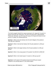
Earth's Magnetic Pole
In this Earth's magnetic pole learning exercise, students use a diagram showing the changes in the magnetic pole of the Earth over time. Students use the given scale of the changes to answer 6 questions about the average speed of the...
Curated OER
Coordinate Grid: Mapping Archeological Sites
Fourth graders discover how to apply the Cartesian coordinate system by figuring out the length and width of their school playground. They determine that pacing is an important tool for the initial mapping of a site. Students conduct a...
Curated OER
Mapping with a Compass: A Simulated Survey
Students use compasses and grids to map the locations of artifacts found in a simulated dig site. In groups, they role-play as future archeologists excavating a school site. Groups begin at their assigned datum and site the artifacts...
Curated OER
The Grand Excursion GPS Map
Eighth graders investigate the uses of a global positioning system. They create waypoints and have to find them using the system. Students must review the geographical concepts of latitude and longitude. The media requirements of the...
Curated OER
Mental Tests
In this ratio activity students use mental math to find the ratios in problems about people, distance, length, and products.
Curated OER
The Pilgrims
Students use distance measuring tools to follow directions and chart the path the pilgrims made from Plymouth, England to Boston, Massachusetts. In this Pilgrim voyage lesson plan, students use a map to chart the distance traveled by the...
Curated OER
Geography Journey
Fourth graders examine the geographic features that define places and regions and answer questions about the state of California. They discuss the components of a map legend and answer worksheet questions using a map of California as a...
Curated OER
Location, Location
Third graders draw and interpret simple scale maps, use maps to move around efficiently or plans to propose actions. They use of a compass to specify and find directions. They display and discuss a map of the local region.
Curated OER
A Contouring We Go
Students examine the built environment and infrastructures of their community by constructing contour equipment, using the equipment, and comparing their results to current topographical maps of the same area


