Curated OER
Reading Comprehension 5: Level 8
Why is an atlas called an atlas? Because it is named for the Greek Titan, Atlas, of course. Young readers learn all about Atlas and atlases in a short passage used as the basis of a reading comprehension exercise. After responding to...
Curated OER
Reference Materials
After a class discussion where kids share how they find answers to their questions, learners explore the world of reference materials such as, an atlas, an almanac, and an encyclopedia. The Internet is also discussed as a way to access...
Curated OER
Finding Your Way Around the World
Students plan a trip around the world and create a PowerPoint presentation of the journey. In this map, atlas, and technology instructional activity, students plan a trip around the world in which they avoid using an airplane. Students...
Curated OER
The Rivers and Lakes of Alberta
Students are introduced to the online Atlas of Canada and they identify the lakes and major rivers of Alberta.
Curated OER
Discovering Dinosaurs: Planning your Summer Vacation
Students use the online Atlas of Canada to gather information about places in Canada.
Curated OER
Where Will You Go?
Fifth graders research and plan an imaginary vacation. In this travel planning lesson plan, 5th graders work in pairs to use an atlas, calendar, review airplane schedules, encyclopedias, magazines, and the Internet to research...
Rainer Goebel
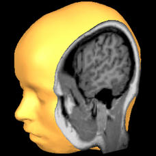
Brain Tutor 3D
The human brain is staggeringly complex, and its structure can seem impossible to grasp. This user-friendly app allows for exploration of the brain's anatomy, providing nomenclature, 3-D mapping, and functions.
Curated OER
Mapping the Most Common U.S. City Names
Pupils discuss the most common U.S. place names. They map the locations of U.S. cities with the most common names and use an atlas, or an online map tool such as MapQuest or Yahoo Maps.
Curated OER
Native Knowledge
Students investigate what type of climate and physical features certain Indigenous groups live in using an atlas and a provided worksheet. They then match the tribe and its location to the sustainable stategy employed in agricultural...
Curated OER
Test Your Research Skills- More Interesting Place Names in England, Scotland, and Wales
In this research skills worksheet, students examine a list of names of 20 towns and villages in England, Scotland, and Wales. They use an atlas of Great Britain to find any fake names and place a mark in the box next to it.
Curated OER
Give Me Some Latitude
In this latitude activity, students use an atlas or other reference to respond to 4 multiple choice questions about the equator and the poles.
Curated OER
Diversity
Fourth graders discover cultural heritage by investigating the Aboriginal community. In this Canadian History lesson, 4th graders identify the First Nations of Canada and research them using an atlas and the web. Students create a First...
Curated OER
Glacier Basics
Students are introduced to the powerful nature of glaciers. Using an atlas, they read the section on glaciers and examine pictures of before and after the glacier moved through an area. In groups, they complete a worksheet on the role...
Curated OER
Rainforest Data
In this geography worksheet, students use the climate data given to create a temperature line graph and rainfall bar graph for each of three locations given. Then they use an atlas to compare their graphs and draw conclusions about the...
Curated OER
Borah Peak Earthquake
learners use the internet, an atlas map, and other sources to explore a map of Idaho. They locate the Lost River Range and Mt. Borah. Students read the atlas map to locate earthquake faults, find the magnitude, fault, and epicenter of...
Curated OER
Destination Investigation!
Students interpret a map or Atlas. They determine latitude, longitude, and absolute location and create and evaluate a travel itinerary. They identify the benefits and drawbacks of an itinerary and conduct online research as a means to...
Curated OER
Scale/Ratio
Investigate the use of ratios in scale drawings. Learners scale objects up or down using ratios then find the actual size of something using ratios. They apply their knowledge of ratios as they make their own telescopes in science class....
Curated OER
Locating Information Quickly in a Variety of Resources
Here is a instructional activity which may be best suited for a library science teacher, or one that can be done by a regular teacher when in the library. In it, learners explore the best ways to use print and electronic resources to...
Curated OER
Sarah, Plain and Tall Study Guide
Patricia MacLachlan’s award-winning novel, Sarah, Plain and Tall, is the focus of a comprehensive study guide. For each chapter, readers answer fact-based and interpretative questions, define and use vocabulary words in a sentence, and...
Curated OER
Draw an Inch, Walk a Mile
Learners work in small groups to solve the problems presented. The main project, mapping the classroom, use these discussions to collaborate in creating a tangible demonstration of their understanding.
Curated OER
A Contouring We Go
Students examine the built environment and infrastructures of their community by constructing contour equipment, using the equipment, and comparing their results to current topographical maps of the same area
Curated OER
Think GREEN - Utilizing Renewable Solar Energy
Students use data to find the best renewable energy potential. In this solar energy lesson students import data into Excel and explain how solar energy is beneficial.
Curated OER
Maryland’s Chesapeake Bay Landscape Long Ago and Today
Combine a fantastic review of primary source analysis with a study of Captain John Smith's influence on the Chesapeake Bay region in the seventeenth century. Your young historians will use images, a primary source excerpt, and maps...
Curated OER
Word Reference Materials
A class discussion on reference materials opens up a lesson plan on how to use these important resources. They discover that dictionaries, glossaries, and thesauruses are called word reference resources, and they practice using them. The...


