Curated OER
Establishing Borders: The Expansion of the United States 1846-48
Students investigate how the United States acquired land after the Revolutionary War ended. For this establishing borders lesson, students use maps to identify territories acquired by the US and the states that later developed. Students...
Curated OER
Investigating Latitude and Longitude
Students examine the lines of latitude and longitude on a map, and explain why these lines might be useful. In this lesson students also explore websites that provide information to improve their understanding of how and why latitude and...
Curated OER
"Water is Life" Global Water Awareness
Students examine and calculate the percentage of potable water remaining on the earth. In this ecology and geography lesson, students brainstorm the main factors affecting water distribution. Students use mathematical problem solving to...
Curated OER
Social Justice-Water in Developing Countries
Students explore how water shortage affects everyday life. In this social justice lesson, students discuss information about water shortage in Ghana. A water shortage simulation/game is played in which a "Canadian" team starts with a...
Curated OER
Walking For Water
Students investigate how third world countries get their water. In this water lesson, students research how countries like Kenya and Ethiopia get their water supply. Students participate in an experiment to role play how difficult it is...
Curated OER
Is the Hudson River Too Salty to Drink?
Learners explore reasons for varied salinity in bodies of water. In this geographical inquiry lesson, students use a variety of visual and written information including maps, data tables, and graphs, to form a hypothesis as to why the...
Curated OER
Rising Sea Levels: UK and Bangladesh
Learners explore the possible effects of global warming. In this geography/global warming lesson, students identify regions using an atlas and complete a global warming worksheet. Learners perform an experiment in which they simulate...
Curated OER
Out of Old England in the 1630s-Flat Me Project
Students write letters to penpals. In this geography/literacy lesson, students become penpals with a classroom in England to learn about customs and society across the ocean. Flat Stanley by Will Holton is read aloud, and students...
Curated OER
Our Changing Community
Students investigate how communities grow and change. In this communities lesson, students discuss how their community has changed and construct a model of a community.
Curated OER
"Yarning" About Latitude and Longitude
Students identify various locations using latitude and longitude. In this map skills lesson, students use yarn and labels to create a "human globe." Students identify the Prime Meridian, the Equator, and Northern and Southern Hemisphere.
Curated OER
Understanding Biodiversity Via Ecological Footprints
Sixth graders investigate the ways in which human beings impact the environment and ecology through the calculation of their own ecological footprint, discussion questions pertaining to biodiversity and potential imbalance hazards, and...
Curated OER
Geography Puzzles
Learners study the continents of the world. In this Internet geography lesson, students connect to online mapping games. Learners collaborate in order to develop their understanding of world geography, including countries and capital...
Curated OER
Designing a Study
Students explore features to consider when designing a scientific study. In this science research lesson, students examine different methods of data collection and consider which method would be appropriate for determining how many types...
Curated OER
Hide and Seek with Geocaching
Students locate objects using a Global Positioning System. In this global geography lesson plan, students explore latitude and longitude using a GPS in order to locate objects.
Curated OER
The Monarch Butterfly Watch
Students explore monarch migration through the Journey North web site. In this butterfly lesson plan, students use the internet to identify a butterfly's migration pattern. Students write in electronic journals.
Curated OER
Passport to the World Field Day
Students participate in a variety of cultural activities from around the world. In this multicultural instructional activity, students visit a variety of "stations", each representing a country. Students learn facts and engage in a...
Curated OER
Archaeology: Digging in the Classroom
Students explore how an archaeologist works and makes discoveries. In this archaeology lesson, students participate in a simulation in which they excavate broken pottery. Students use measurement, geometry, and observation skills during...
Curated OER
Mapping Perceptions
Learners create and read maps. In this map skills lesson plan, students draw a map of their neighborhood, then use skills acquired during map-making to interpret a classmates map and a map of the Ming Dynasty.
Curated OER
Deduction
In this using the process of deduction worksheet, students read the character's multiple plans, observe street maps of area attractions and stores, and use only six sections of the road to show each route. Students answer 2 questions.
Curated OER
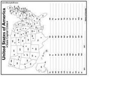
United States Capital Cities
In this identifying the United States Capital cities worksheet, students use a United States map and a list of state abbreviations to write each state' s and the District of Columbia's capital city. Students write 51 answers.
Curated OER
Asia Outline Map
In this Asia outline map instructional activity, students explore the continent as they label the 47 countries. The countries are numbered and lines for the answers are provided on the sheet.
Curated OER
Australia/Oceania Outline Map
In this Australia and Oceania outline map activity, students explore the region of the world as they label the 14 countries. The countries are numbered and lines for the answers are provided on the sheet.
Curated OER
Make Your Map
In this map making worksheet, students make their own maps, draw symbols and place them in the map key area, and draw a compass rose to show directions for the map.
Curated OER
Where in the World Is Mrs. Waffenschmidt? #3
In this solving the location worksheet, students read a paragraph of clues about the tower Mrs. Waffenschmidt is visiting and the country where it is located. Students write 1 short answer.


