Curated OER
Australia Map Resource Sheet
In this Australia map resource worksheet, students use the map of Australia to supplement their study of the country. They see a map labeled with Australian cities, and the surrounding countries and water bodies.
Curated OER
The Geography of Land Planning
Students utilize simple maps to plan a town, supply water resources and then fit their towns into the a larger community. They assess how hard it is to plan a town by group decision-making as well as the services required to help a town...
Curated OER
How Many Ways Can You Say Merry Christmas?
Students create a multicultural holiday bulletin board map! students research and study saying Merry Christmas in different languages. They correctly locate the countries on a world map.
Curated OER
We've got the whole world in our hands
Students explore spatial sense in regards to maps about the globe. In this maps lesson plan, students label oceans, locate the continents and poles, follow directions, and explain the symbols on a map.
Curated OER
The Adventures of the Alamo
Fifth graders demonstrate their ability to locate San Antonio on a Texas map, use the Internet to conduct research on the War of the Alamo, and simulate the past during dress-up day and Pinata Day.
Curated OER
Putting the World in Perspective
Students work in small groups to: make a mental map of the world by tearing paper shapes of the seven continents and locating them on a flat surface in their relative positions, compare their finished mental map to a reference world map,...
Curated OER
Four Corners Mystery: Where In The World Are We?
Students research and describe various locations around the world using five fundamental themes of geography.
Curated OER
Nunavut, Our Communities
Students locate the communities of Nanavut on a territorial map and identify community characteristics. They research the online Atlas of Canada
Curated OER
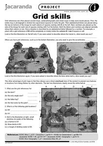
Grid Skills
In this geography worksheet, students use grid references on a map to locate places in the pictures given. They also identify another advantage of using a grid map, which they have an overhead view of the content to prevent any features...
Curated OER
Great Cities of the Middle East
Students explore the cities of Cairo, Istanbul, Jerusalem, Mecca and Tehran. In this Middle East lesson plan, students complete a map, research one of the five the cities and prepare a presentation that includes details about the...
Curated OER
Where in the World is Mr. Fultz?
Students use maps and other geographic resources to learn about their world while problem solving. They read clues each day and use classroom resources to narrow down where the prize is located.
Curated OER
The High and the Flighty
Young scholars study women aviators and act out a talk show-style interview with one of them. They plot Amelia Earhart's flights on a map.
Curated OER
What State Are You In?
Students identify the major U.S. cities. In this U.S. geography instructional activity, students work in pairs and use game cards to name various cities in the United States.
Curated OER
On the Road with Marco Polo
Young scholars follow Marco Polo's route to and from China. They explore the geography, local products, culture, and fascinating sites of those regions. They record their findings.
Curated OER
WHERE DOES OUR FOOD COME FROM?
Students examine the sources, location and availability of local food, develop mapping skills, interact with Elders to gain pertinent information, and examine subsistence issues of the past and present.
Curated OER
Discovering Your Heritage
Learners interview a family member about their heritage. They listen to and record part of their family's oral history. Students also create and label a family tree going back a minimum of two generations and compare and contrast...
Curated OER
Lake Tahoe Then and Now
Young scholars investigate the differences in Lake Tahoe from the past to the present. In this geography lesson plan, students read the book Washoe Seasons of Life and identify the descriptions of the land and lake. Young scholars create...
Curated OER
Land Plan Challenge
Students use maps to plan towns, being conscious of water resources. For this geography and land planning lesson, students create collaboratively in small groups towns using maps. At the conclusion of the activity, students build their...
Curated OER
You're Invited to a Ceili: Exploring Irish Dance
Students recognize a Ceili as an Irish dance of celebration and investigate Ireland while studying the dance. In this Irish dance lesson plan, students search the geography of Ireland, read poetry, identify costumes, draw and...
Curated OER
Countries of Africa
Students investigate the different countries of Africa. In this African geography lesson, students choose an African country to investigate and construct the country's flag. Students use a map of Africa to color in their country.
Curated OER
Washington D.C.
Learners research monuments in Washington, D.C. In this geography lesson plan, students research one monument and use the Internet to gather information. Learners create a three-dimensional model of their monument.
Curated OER
Continent of Africa
In this geography worksheet, learners examine a map of Africa and read about the characteristics of the continent. They use the map and information to answer 10 online fill in the blank questions.
Curated OER
Chinese Lion Dance
Students celebrate the Chinese New Year and listen to the story behind the Chinese Lion Dance. In this Chinese New Year lesson, students research the geography and culture of China. Students create puppets, dance the Lion...
Curated OER
Oil Dependency Among Nations
Students research oil dependency amongst different nations in the world. In this oil dependency lesson plan, students use maps to locate oil sources, consider government actions on oil, and predict U.S. oil dependency.


