Curated OER
Title: Rivers as Borders
Students are introduced to the concept of borders. They read maps and identify rivers that separate different countries and states. They examine how or why a landform such as a river border might be the reason for different cultures.
Curated OER
Crossing Borders, Crossing Boundaries?
Students explore how the United States government is using biometrics to secure American borders. They examine the pitfalls of biometrics programs and propose possible ways to strengthen the program.
Curated OER
Changing Borders
Students explain that the boundaries between countries are not permanent, then analyze current events and stories as examples of cooperation and conflict. They describe a place using physical and human characteristics.
Curated OER
Solving the Puzzle
Students create a map showing the United States borders at a specific period in history and produce three questions to be answered by examining the map. They also write a productive paragraph explaining who, what, when, where, how/why a...
Curated OER
Setting Boundaries
Students investigate the determination of the boundaries of various countries. They work in small groups to research a country's political history and past boundary issues and territorial disputes.
Curated OER
Diseases Without Borders
Students use the European Union's struggle with Mad Cow Disease as a starting point to study the spread of infectious diseases across geographical boundaries.
Curated OER
Drawing The Line
Students explore how arbitrary borders affect communities by participating in two hands-on activities and by reading about and discussing a community divided by national borders. They investigate the borders of their own neighborhoods.
Curated OER
No magic borders
Middle schoolers discuss what they have heard about pollution. They explore the purposes and limitations of political boundaries and borders and identify some of the causes and effects of pollution.
Curated OER
Mending the Rift
Learners determine what factors identify a country's political borders. After reading an article, they investigate questions surrounding the Great Rift Valley. On a map, they trace the valley from Asia through Africa and research the...
Curated OER
This Land is Your Land
Students consider the concept of borders and their development by looking at maps and documents. They create a presentation highlighting a current border dispute and propose solutions.
Curated OER
The borders of Europe. Geographically location or cultural artifice?
Twelfth graders discuss where they regard the boundaries of Europe to be. They raise their awareness that "Europe" may be more of a cultural construct than geographical defined continent.
Curated OER
Life on the Border
High schoolers discuss different types of boundaries. They research the United States/Mexico border and answer questions about their findings. They create collages, posters, or multimedia presentations showcasing various areas of concern...
Curated OER
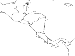
Central America Map wtih Country Borders
In this blank outline map worksheet, students explore the political boundaries of Central America and the nations there. This map may be used in a variety of classroom activities.
Beverly Hills High School
Mapping Napoleon's Empire at Its Height (1812)
The complicated political history of Europe becomes apparent as young historians create a map of the borders of France when Napoleon's Empire was a its height in 1812.
Curated OER
Book: Germany
Students, after reading Chapter One in the book, "Germany," analyze and recreate the political boundaries as well as the physical features of the nation of Germany with the assistance of play-doh or salt dough. In groups, they create...
Curated OER
Crossroads: Chicano Identity and Border Culture
Students identify and explore complex ways that the theme of "frontiers" or socio-political borders affect Chicano identity in the US and examine notions of "resistance" and "affirmation" as a fundamental ideology in Chicano life,...
Curated OER
A Wall for Peace?
Young scholars give examples that demonstrate how people are connected to each other and the environment. They idnetify current or historic conflicts and explain how those conflicts are or were influenced by geography. Students explore...
Curated OER
Hungary: The Landscape
Learners work in small groups to create a topographic map of Hungary. The map will include labeled line drawing of the bordering countries. Hungary should be three dimensional, made of salt and flour clay. The mountains, plains and...
Curated OER
Italy: The Landscape
Students work in small groups to create a topographic map of Italy. They must include labeled line drawings of bordering countries and bodies of water. Students use salt and flour clay to make Italy three dimensional, showing the many...
Curated OER
Malta: The Landscape
Students work in small groups to create a topographic map of Malta. They must include labeled line drawings of bordering countries and bodies of water. Students use salt and flour clay to make Malta three dimensional, showing the nearest...
Curated OER
The Big Circle
Students explore geography by participating in a mapping activity. In this concentric ring instructional activity, students utilize a poster board, string and markers to identify their current location within the entire world. Students...
Curated OER
BOUND TO BE NEW HAMPSHIRE
Students identify neighborhood, town, and state boundaries. They distinguish between natural and man-made boundaries. They identify major state geological features and explain how NH boundaries have changed over time.
Curated OER
Mapping the Middle East
Students examine how the countries of the Middle East were created. They explore the influence of various political and geographic factors in their creation. They list the things they should consider in deciding how to draw new borders...
Curated OER
A New Federation
Students describe the relationships between state and federal parliaments in Australia. They identify responsibilities shared between federal and state and territory governments. Students explore an alternative federal structure by...


