Curated OER
The Royal Art of Benin
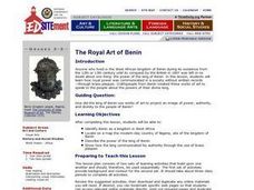
Students investigate how the king of Benin used brass plaques to project an image of power to the people of Benin. They locate Benin on a map, explore various websites, and create a paper wall plaque that conveys symbols of power.
Curated OER
Using Vegetation, Precipitation, and Surface Temperature to Study Climate Zones
Using NASA's Live Access Server, earth scientists compare the temperature, precipitation, and normalized difference vegetation index for four different locations. They use the data to identify the climate zone of each location using...
CK-12 Foundation
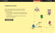
Pythagorean Theorem to Determine Distance: Neighborhood Map
Find the distance between various locations in a neighborhood. Scholars use the interactive to find distances between locations on a map. The map is overlaid onto a grid to provide coordinates for each location, and pupils apply...
CK-12 Foundation
Midpoint and Segment Bisectors: Midpoint Map
Discover how to find a midpoint with a conceptual exploration. Scholars manipulate a point to determine the location of a midpoint on a straight line distance between two locations. Later questions extend to determine the...
Describing Egypt
Temple of Kalabsha (Temple of Mandulis)
What was the Kalabsha Temple to ancient Egyptians? Discover the importance of the dock and the use of bodies of water to the Egyptian people. The resource includes side panels with important information about the history of the location.
Curated OER
Storm Clouds-- Fly over a Late Winter Storm onboard a NASA Earth Observing Satellite
Students study cloud data and weather maps to explore cloud activity. In this cloud data lesson plan students locate latitude and longitude coordinates and determine cloud cover percentages.
Curated OER
Maryland’s Chesapeake Bay Landscape Long Ago and Today
Combine a fantastic review of primary source analysis with a study of Captain John Smith's influence on the Chesapeake Bay region in the seventeenth century. Your young historians will use images, a primary source excerpt, and maps...
Indian Land Tenure Foundation
More Tribal Homelands
Here is a very fun idea that introduces young learners to how geographical location affects cultural development. They are introduced to four areas where Native Americans have lived in the past by reading stories and examining images....
EngageNY
Sequencing Translations
Investigate the results of multiple translations on an image. Scholars use vectors to perform a sequence of translations in the seventh lesson of 18. They examine the results and determine the importance of using a sequence rather than a...
Curated OER
Across the United States- Home Learning Activity
For this home-school United States map worksheet, students work with a family partner as they study a map of the United States. They talk about the states they have visited, play a game by giving each other clues about states, and write...
Curated OER
Bust Of Virgo, Bust Of Pisces
Students analyze the relief designs of Petra and design their own personal sacred image in the same style using plaster of Paris or Model Magic. This instructional activity should be completed within 45-minutes of starting construction...
Curated OER
Salmon Stories
Work on author's purpose with this lesson, which focuses on sequence of events and audience as well. Middle and high schoolers describe the 50 State Quarters Program for background information. After discussing the images on the...
Curated OER
National Marine Sanctuaries Shipwrecks
Junior oceanographers access the Channel Islands National Marine Sanctuary Shipwreck Database and plot the locations of several shipwrecks. Shipwrecks are always an enthralling subject and this activity allows your learners to act as...
Book Units Teacher
Sentence Unit
Imagine using history to teach grammar. This 178-slide PowerPoint presents an amazing collection of images and historical information about the settlement of Tennessee and about famous residents like Daniel Boone. Viewers...
CK-12 Foundation
Plots of Polar Coordinates: Submarine Sonar
Find the location of enemy submarines with a sonar display that doubles as a polar coordinate system. Pupils find polar coordinates that would be the same location of plotted submarines. They then determine multiple polar...
CK-12 Foundation
Midpoint and Segment Bisectors: Finding Treasure with Geometry
Send your class on the hunt for a buried treasure and apply geometry skills along the way. An engaging lesson uses direction and midpoint locations to find the location of a treasure. Videos provide background information to complete the...
CK-12 Foundation
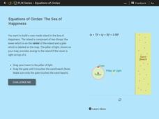
Equations of Circles: The Sea of Happiness
Map this! Help your young mathematicians draw a circular island on a map. Given specifics of the location and size of an island on a map, pupils transform a circle to meet the given requirements. They then determine the location of the...
CK-12 Foundation
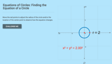
Equations of Circles: Finding the Equation of a Circle
It's all about location and size. With the aid of the interactive, pupils explore the relationship between the location and size of a circle and its equation. The learners use that relationship to determine the equation of a circle given...
Curated OER
Angles All Around Us
Explore with your class the characteristics of acute, obtuse, right, complementary, and supplementary angles. They take digital photographs around the school and identify the angles in the images. Uisng software, they label and...
Curated OER
Playground Mapping
Students convert their physical models of a playground from a previous lesson into a map of the playground that includes a scale and key. They examine and discuss examples of maps, view an image to map photo essay, and create a map using...
Curated OER
Poetry In Motion
Explore poetry with your class by having them film themselves reading different types of poems. They explore different elements in all types of poetry. They choose images to accompany their poems and learn to create video presentations...
Curated OER
Every Building Tells a Story
Examine images from past that depict buildings and towns from their own communities, and compare images with photographs taken at present locations, interview local architect and compare role of 19th Century architect to 21st Century...
Curated OER
Comparing Visual Interpretations and Actual Events: War & Battle
A Venn Diagram is used to compare artistic and historical representations of a single event. Young analysts view the provided images, read textbook descriptions, and discuss the validity of each representation in terms of bias and...
Curated OER
About Life: The Photographs of Dorothea Lange Going to the Promised Land
To better understand the migrant experience during the Great Depression, pupils analyze two primary resources: photographs by Dorothea Lange and a U.S. Map that shows the Dust Bowl. They compare and contrast Lange's images to Steinbeck's...
