Teach Engineering
Where Are the Plastics Near Me? (Mapping the Data)
The last activity in a nine-part series has teams create a Google Earth map using the data they collected during a field trip. Using the map, groups analyze the results and make adjustments to the map to reflect their analysis. A short...
Radford University
Escape from the Zombie Apocalypse - Exploring Quadrilaterals through Google Maps and Google Earth
Prepare for the zombie apocalypse ... by studying quadrilaterals? Given a map of an imaginary town, scholars identify quadrilaterals created by streets. They then use Google Earth and Google Maps to find parallelograms, rectangles,...
Curated OER
Grid Frame Mapping
Students map and describe small area of the schoolyard and discuss habitats.
Curated OER
Introduction to Field Mapping with a Compass and Pace
Students practice using compass and calibrate their own pace, take field measurements of pre-set course with compass and pace, convert measurements into map, using angles and vectors, and make composite class map by adjusting different...
Curated OER
6: Parts of a Flower
Students draw and label the parts of a flower using a coin from the Northern Mariana Islands. In this flower parts lesson, students look at a transparency of the reverse side of a quarter from the Mariana lslands. They discuss the...
EngageNY
How Do Dilations Map Angles?
The key to understanding is making connections. Scholars explore angle dilations using properties of parallel lines. At completion, pupils prove that angles of a dilation preserve their original measure.
Teach Engineering
Let's Get it There Fast
Are planes the best shipping method? Using maps, pupils determine the fastest mode of transportation between two cities. Given a list of items to ship, groups decide the best shipping method to finish the 18th segment of a 22-part unit.
Council for Economic Education
Banks and Credit Unions (Part 1)
Imagine you have money you want to save ... where do you put it? Pupils investigate the similarities and differences of banks and credit unions as they determine where exactly to place their hard-earned money. Through a WebQuest, they...
Curated OER
Constellation Mapping
Students plot constellations on a grid map. They discuss the various ways early explorers planned their travels. Students identify and recognize major constellations. They color their maps and take them home to try to find various...
Curated OER
You Are Here
Students map local places and learn to use scale and distance. In this mapping lesson plan, students map their school and a favorite place. Students recreate their maps showing distance and scale sizes. Students locate their location...
Curated OER
Exploring History Through Photographs
A fascinating series of four lessons on how photography and society have evolved over time. These lessons bring in elements of art, math, social studies, and geography. Everyone gets to make maps, look at old photos, and take part in a...
Howard Hughes Medical Institute
Measuring Biodiversity in Gorongosa
Take your biology class' understanding of biodiversity to a whole new level! Ecology scholars use data to calculate three different diversity indices based on the organisms in the Gorongosa National Park. The four-part activity uses an...
EngageNY
Applications of Congruence in Terms of Rigid Motions
Corresponding parts, congruent parts, congruent corresponding parts—what does it all mean? The resource challenges pupils to identify corresponding parts for pairs of figures. It uses examples of figures that undergo rigid...
Teach Engineering
What's Wrong with the Coordinates at the North Pole?
Here is an activity that merges technology with life skills as individuals use Google Earth to explore the differences between coordinate systems and map projections. The self-guided worksheet is the fourth segment in a nine-part unit....
Curated OER
Draw an Inch, Walk a Mile
Students work in small groups to solve the problems presented. The main project, mapping the classroom, use these discussions to collaborate in creating a tangible demonstration of their understanding.
Curated OER
Summer Trip
Fourth graders search for information and directions to specific cities from their homes, figure cost of trip when given miles per gallon, distance, and cost per gallon of gas, develop outline budget for summer trip, and draw and label...
Curated OER
Application of Graph Theory
Students investigate different online tutorials as they study graphing. For this graphing lesson, students apply the concept of graphs cross curricular and use it to make predictions. They define the purpose and theories behind graphs.
Curated OER
Is the Hudson River Too Salty to Drink?
Students explore reasons for varied salinity in bodies of water. In this geographical inquiry lesson, students use a variety of visual and written information including maps, data tables, and graphs, to form a hypothesis as to why the...
Curated OER
Labeling a Map of the British Isles and Elapsed Time
In this map work and elapsed time activity, students label England, Scotland, Wales, and Ireland on a map. They calculate the elapsed time of a delivery that is described in a word problem that is broken down into four parts.
Concord Consortium
The Six Faces of Amzora
Here's a task that is out of this world! Given a description of a fictional cube-shaped planet, scholars answer a set of questions about the planet. They create a two-dimensional map and consider the distances between locations on the map.
Mathematics Assessment Project
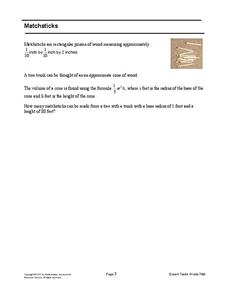
Matchsticks
How many matchsticks can be made from a single tree? That is the problem facing middle schoolers. Scholars first determine the volume of a matchstick given its dimensions, and then use this information to estimate the number of...
Curated OER
Corresponding Parts of Congruent Triangles
Students identify different parts of a triangle. In this geometry activity, students differentiate between similar and congruent triangles. They use the navigator to crate a visual of the different parts of a triangle.
Illustrative Mathematics
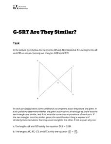
Are They Similar?
Learners separate things that just appear similar from those that are actually similar. A diagram of triangles is given, and then a variety of geometric characteristics changed and the similarity of the triangles analyzed. Because the...
August House
The Ogre Bully
English language arts, math, science, dramatic arts, and cooking; this lesson plan has it all! In this multidisciplinary resource, your scholars will take part in a read aloud of The Ogre Bully by A.B. Hoffmire and have a grand...


