T. Smith Publishing
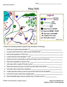
Map Skills
Help younger learners develop their map skills with this simple worksheet, which includes 12 questions utilizing a map legend that involves highway markers, population indicators, and other landmark signs.
Curated OER
Weather Map Challenge
In this weather worksheet students use a weather map to answer given questions. Students answer questions using map symbols and make predictions based on map. Students create additional questions with answers using the same map.
Super Teacher Worksheets
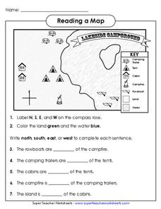
Reading a Map
Young geographers improve their map skills by practicing locating the cardinal directions on a map, identifying symbols on a map key, and describing where objects on the map are located relative to other locations.
Richmond Community Schools
Map Skills
Young geographers will need to use a variety of map skills to complete the tasks required on this worksheet. Examples of activities include using references to label a map of Mexico, identify Canadian territories and European countries,...
abcteach
Street Mapping
What's around the block? Or down the street? Ask your pupils to tap into their map skills by drafting the area around their home and school.
Owl Teacher
Introduction to World of Geography Test
Assess your learners on the five themes of geography and the most important key terms and concepts from an introductory geography unit. Here you'll find an assessment with 15 fill-in-the-blank and 14 multiple-choice questions, sections...
Curated OER
How To Read A Map
In this map skills worksheet, students view a map and answer five short answer questions by using the map key as a guide.
Curated OER
Topographic Mapping Skills
For this geography worksheet, students read an excerpt about topographic maps and why they are useful for various jobs. They also respond to eleven questions that follow related to the excerpt and locating specific map points on the map...
Curated OER
Regents High School Examination: Physical Setting Earth Science 2009
Junior geologists address 50 multiple choice questions and 35 short answer questions about the earth system. Plenty of visuals are included for interpretation: diagrams, graphs, maps, photographs, laboratory setups, weather symbols, and...
Curated OER
The Roman Empire-Map Activity
In this Roman Empire worksheet, students complete a map activity in which they label and color civilizations, countries and physical features as instructed. There are no maps included.
Curated OER
Make a Map
For this mapping activity worksheet, students finish the map by following the 5 directions and using the map key. Students the map key, scale, and an inch ruler for help.
Curated OER
Making Maps
For this map making worksheet, students learn about the science of making maps, which is cartography. They then answer the 11 questions on the worksheet. The answers are on the last page.
Curated OER
Mapping Exercise
For this mapping worksheet, students are given data of children exposed to health risks and their geographical location. Students plot each child's home and the risk factors using an (x, y) grid. They answer 2 questions about the...
Curated OER
Make Your Map
In this map making instructional activity, students make their own maps, draw symbols and place them in the map key area, and draw a compass rose to show directions for the map.
Curated OER
Map Key
In this map reading activity, students read the map key and then cut our and paste the symbols where they belong on the provided map.
International Technology Education Association
Become a Weather Wizard
Accurate weather forecasting is something we take for granted today, making it easy to forget how complex it can be to predict the weather. Learn more about the terms and symbols used to forecast the weather with an earth science lesson...
Curated OER
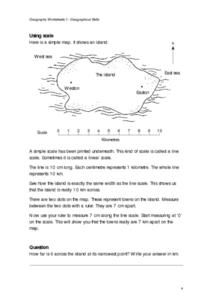
Geographical Skills-- Map Scale
In this maps worksheet, students study a simple map and the scale in kilometres. Students read the directions and answer one question. Students then look at a sketch map of a town and answer 2 questions. Students also read how to show...
Curated OER
Topographic Maps Worksheet
In this geography skills worksheet, students respond to 37 multi-part questions that require them to read and interpret topographic maps.
School District of Palm Beach County
Framed Paragraphs characterization, problem and solution, symbolism, conflict
Support your learners as they work on writing paragraphs by providing graphic organizers, outlines, and frames. Sift through this packet to find the perfect organizers and templates to prepare pupils for writing. The resource...
Curated OER
Map Keys
In this geography worksheet, students identify who a cartographer is and what they do specifically. They study an outline map of a fictitious island and then, respond to the three questions that follow. Finally, students add three more...
Curated OER
Weather Map Challenge
In this weather worksheet, students use a weather map to answer ten questions about the information found on a weather map and what the symbols mean. They find the cities with the highest and lowest temperature as well as the cities...
Oregon State
World Map of Plate Boundaries
Young geologists piece together the puzzle of plate tectonics in an earth science lesson. Given a physical map of the world, they search for land formations that indicate the location of different types of plate boundaries.
Curated OER
Interpreting Algebraic Expressions
Interpreting algebraic expressions is a fundamental skill in beginning algebra. This activity approaches the task in numerous ways. First, learners assess their understanding with a short worksheet on converting between words and...
Curated OER
Jordan's Neighborhood: Using a Compass Rose
A neighborhood map is a great way to practice compass rose and key skills! Use these 2 worksheets to introduce these concepts through reading and comprehension activities. First, students look at 3 compasses, circling their favorite and...
Other popular searches
- Weather Map Symbols
- Weather Map Weather Symbols
- Topographic Map Symbols
- Map Symbols First Grade
- Teaching Map Symbols
- Geography Map Symbols
- Os Map Symbols
- Map Symbols and Neighborhood
- Location/ Map Symbols
- Wetaher Map Symbols
- Reading Weather Map Symbols
- Weather Map Symbols Exercise


