Curated OER
Thinking Critically about Geography
In this map reading activity, students answer 2 critical thinking questions about a map shown. Page has links to additional resources.
Curated OER
Map Keys
Third graders examine maps and map keys. In this locating map features lesson, 3rd graders use crayons, markers and colored pencils to label maps. Students work in partners to read map keys and locate given places and things.
Curated OER
Map Scale and the Pioneer Journey
Fourth graders, using a map, ruler and calculator, determine the distance the pioneers traveled from Nauvoo, Ill. to the Salt Lake Valley.
Curated OER
European Union Map Quest
Sixth graders identify countries of the European Union. They locate countries of Europe on a map and pair with a student to complete a blank map of Europe. They label each country and complete worksheets for the European Union. They...
Curated OER
FUN WITH MAPS
Fifth graders learn map skills by showing the routes they travel from home to school and using that data to practice map reading and interpreting geographical information.
Curated OER
Map Projections: The Grapefruit Activity
Students partcipate in activities in which they examine different map projections. They discover the positives and negatives of each type. They use grapefruits to help them with the different types of map projections.
Curated OER
Memorable Maps
Students draw an assigned map from memory about the United States or any other region they are studying. In this maps lesson plan, students draw a map from their memory at the beginning of the year, and do the same assignment at the end...
Curated OER
Map Projections
Students view examples of various map projections using a website. Students record differences between the map projections. Students discuss uses for the various map projections and the differences between the maps they viewed. ...
Curated OER
Mapping Electricity
Students complete Internet research and use their map reading skills to learn about how the United States creates and uses electricity in different states. In this energy sources lesson, students study the mini map of energy usage in the...
Curated OER
United States Map - Lesson 7: Four Main Directions
Students locate the North and South Poles, and learn the definitions of the four directions by using a United States Map and a globe. In this directions lesson plan, students define north, south, east, and west on a map and a globe.
Curated OER
Map Skills
Students examine the nations, battlefields, troop movement of the Germans through Belgium and the location of both fronts during World War I by creating a map. They visualize the strength of the Germans early in the war.
Curated OER
My World
Learners study maps. In this social studies lesson, students draw a map of either their room at home or the route they take to school. Learners label items on their maps.
Curated OER
Hawaii: A Stolen Star
Explore the islands of Hawaii. Investigate Hawaiian culture and compare their personal traditions to Hawaiian traditions. They locate Hawaii on a map and research the history of Hawaii.
Curated OER
Around the Town
In the world of GPS, make sure your kids can still read maps and determine distances between locations. You will need neighborhood street maps, ideally of your class' home turf. Ask kids questions about different locations in relation to...
Curated OER
National Expansion
Students investigate the Manifest Denstiny. They explore how the idea was evident in 19th century American maps. Students brainstorm the relationships between maps and national expansion. They review a map from 1816 that called for...
Curated OER
Create a Migrant's Scrapbook from the First Great Migration
Help young historians personally engage in the stories of African Americans during the Great Migration! Assessing a migration route map, learners create a migrant character's experience, adding details while studying primary sources. A...
Curated OER
You Are Here
Students map local places and learn to use scale and distance. For this mapping lesson, students map their school and a favorite place. Students recreate their maps showing distance and scale sizes. Students locate their location on a...
Annenberg Foundation
America's History in the Making: Classroom Applications One
Someone finds a time capsule 100 years from now, and it includes your family photo album. What would the photos tell that person about you and your place in history? Scholars investigate how artifacts tell stories. Using photos, maps,...
Curated OER
The Mind Map
Learners form a mental map of their residence in relation to school and recreate it on paper showing distance, direction, location and symbols. This lesson is designed to introduce learners to geographic thinking.
Curated OER
By George, I Think We Have It: Bicentennial quarter reverse
Voting is one of the major reasons the US adopted public education. Educate your class populace, they will analyze the images on a bicentennial quarter and think about the contributions George Washington made to the United States. They...
Curated OER
World War II New Guinea Campaign
Although the big picture for this lesson on the New Guidea Campaign of WWII is taking a field trip to the Douglas MacArthur Memorial, you can easily use it as a guide to an independent or group research project as well. However, if you...
Curated OER
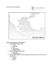
Ancient Greece Map Worksheet
Since the beginning of time, geography has shaped the development of human civilization, and ancient Greece is no exception. This worksheet supports young historians with exploring this relationship as they first identify key land...
Curated OER
Making a Two - Colorable Map
Students make a two - colorable map by following directions given to them. In this map lesson plan, students follow 5 sets of directions and discuss their activity.
Curated OER
Map Studies
Learners analyze maps of Europe, and research and discuss current wars in Europe, and compare them to World War I and World War II.
Other popular searches
- Thinking Maps Math
- Bubble Thinking Maps
- Lessons Using Thinking Maps
- Thinking Maps and Poetry
- Tree Thinking Maps
- Prewriting Thinking Maps
- Thinking Maps Reading
- Sound Thinking Maps
- Writing, Thinking Maps
- Tree Maps Thinking Map
- Rewriting Thinking Maps
- Writing, Thinking Maps, Circle


