Curated OER
Bhutan, the Last Shangri-La: Sandwich Squash: How the Himalayas Were Formed
Students create and record a model of mountain formation. They identify major mountain building formations. Students understand how the Himalaya Mountains were formed, why they are located near Bhutan, and why they are becoming larger.
Curated OER
COMPARE SOILS BY GROWING PLANTS
The student will identify the difference in the rate of plant growth in three soils that vary in organic matter.1. Obtain three to four flowerpots, different types of soil, a record chart, three to five beans for each pot, and water....
Curated OER
Mapping Deep-Sea Habitat
Young scholars create a two-dimensional topographic map and a 3-D model of landforms. In this creative lesson students create 2 and 3-D objects and learn how to interpret the data from these things.
Curated OER
Polygons, Pingos, and Themokarst! Oh MY!
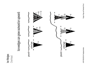
Students complete activities to learn about the common land features in Alaska. In this land study lesson, students study an overhead for permafrost features. Students define ice wedge polygons, thermokarst, and pingos. Students also...
Curated OER
Physical and Human Geography Review Worksheet and Study Guide
In this geography skills worksheet, students respond to 30 short answer questions pertaining to physical and human geography.
Curated OER
Making a Food Web and Learning About Ecosystems
Third graders examine the difference between a food web and food chain. They also examine the importance of the sun in a food web and food chain. Students understand what happens when you remove parts of the chain.
Curated OER
Groundwater Pollution Site Assessment
Students study how a geologist examines a hazardous waste spill using an actual site. They use site data to map the spill, find its source and determine how fast the spill is spreading.
Curated OER
Geography of the Silk Road And the Tokaido Road
Students examine the geographical features of the Silk Road and the Tokaido Road in this introductory lesson on Chinese geography. Small group learning is emphasized and encouraged.
Curated OER
States with Attitude, Latitude and Longitude Dude
Sixth graders identify states whose boundaries are formed by lines of latitude and longitude or natural borders such as rivers. They trace a map of the U.S., and fill in borders, rivers and lines of latitude and longitude.
Curated OER
Three-dimensional cooperative modeling
Learners explore what is present below the surface in order to drill into the ground and record the type of material that the drill brings to the surface. They discuss the benefits and drawbacks of distance communications. Students...
Curated OER
Early Space Missions
In this space missions activity, students read about the launch of the space shuttle Magellan and its exploration of Venus. Students complete 2 short answer questions based on the reading.
Curated OER
Crossing China By Sampan
Sixth graders determine the geographic features that facilitate and prevent communication and commerce between parts of China. They recognize a sampan, the traditional flat-bottomed boat used in Southeast Asia.
Curated OER
Using Soil properties and Vegetation Differences to Hypothesize the Land Use History and Topographic Differences between Two Locations
Ninth graders take soil samples and perform tests on these samples.
Curated OER
Natural Wonders of China And Japan
Students identify some of the attributes of China and Japan and compare and contrast the way Chinese, Japanese, and American artists represent nature in art. The lesson is for upper-elementary classrooms.
Curated OER
Dig Magazine Archeology Quiz #60
For this Dig Magazine archeology quiz, students answer 4 multiple choice questions covering a variety of topics. Page contains answer and additional resources link.
Curated OER
Ring Detectives
Students describe the overall flow of the Gulf Stream, and explain how it affects biological communities in the North Atlantic Ocean.Students describe Gulf Stream rings, and explain how they are formed.Students be abl
Curated OER
NOAA Research Project
Students research any topic relating to the National Oceanic and Atmospheric Administration (NOAA) research cruise that Mrs. Richards be participating in.
Curated OER
Soil Science Study
Students complete an activity by looking and gathering data on plants and soils.
Curated OER
Spinning the Eco Web
Pupils examine the components and relationships of ecoregions and ecosystem management. They define ecoregion and ecosystem, list ecoregions, and participate in a simulation that demonstrates the connections between parts of the ecosystem.
Curated OER
Five Themes of Geography
High schoolers conduct research to determine why geography is important and how it provides information regarding many aspects of the world. They investigate the hemispheres, longitude, latitude and absolute location.
Curated OER
Watershed Island
Students make a clay model and a geographic map of a watershed. They talk about the differences between the two representations and the potential human threats to watersheds.
Curated OER
Where Is That Place?
Students determine the difference between a country, state, and a city while recording the weather conditions for their school in Nebraska. They examine weather for another school in the state while practicing using weather equipment to...
Curated OER
Water Table
Students study the meaning of a water table and how it contributes to the existence of streams, swamps, and lakes in Nebraska. They conduct an experiment and complete a diagram of the hydrologic cycle.
Curated OER
Physics: Visualization of Hydrogen Wave Functions
Students explore various methods for visualizing the results of hydrogen wave function. They observe trends using a polar plot tool and make plots for the first three energy levels of the radial wave function for hydrogen. Students apply...


