Curated OER
Names and Places
Students explore where jobs are done. In this careers and geography lesson, students locate places in Canada on a map and list jobs that are done in their area of Canada. Lesson includes extension and differentiation ideas.
Super Teacher Worksheets
United States of America
Here is the perfect assessment to test your young learners on labeling the 50 states! Each state is given a number on a blank map of the United States, and a second page lists the numbers in order for learners to identify.
Curated OER
Indiana State Map
In this state maps worksheet, students identify the state of Indiana and fill in the state capital, major cities, and other attractions in the state.
Curated OER
Social Studies: Where I Come From
Students research the countries of their origins and examine life there today. They write family travel logs by interviewing family members about their heritages, and they visit the Xpeditions Website for online resources about their...
Curated OER
Social Studies:
Learners identify various types of breads fromother countries and locate them on maps. In small groups, they make story maps of books that mention bread and make books resembling sandwiches. Students have a bread tasting party and...
Curated OER
Learn the States and Postal Abbreviations
If you are preparing to cover the 50 states with your class, you don't want to miss this resource. It includes an excellent set of worksheets through which learners practice identifying states from their abbreviations and placing those...
Syracuse University
Erie Canal
While canals are not the way to travel today, in the first half of the nineteenth century, they were sometimes the best way to move goods and people. Scholars examine primary sources, including maps and pictures, to investigate the role...
National Endowment for the Humanities
Hopi Place Names
What's in a name? Historians consider the question as they examine places important to the Hopi people and the meanings of their place names. Included worksheets include maps and charts to help class members examine the geography of Hopi...
Scholastic
Volleyball Road Trip
Review coordinate mapping with your young geographers by matching cities on a volleyball team's road trip itinerary to their appropriate coordinate locations.
Curated OER
Opening Doors to Social Studies with Children's Literature: The Desert Alphabet Book
Students explore the geography of the United States. In this social studies instructional activity, students identify the major deserts on a map of the United States.
Curated OER
My World
Students study maps. In this social studies lesson, students draw a map of either their room at home or the route they take to school. Students label items on their maps.
Curated OER
Read a Fall Foliage Map
Students examine the purpose of a color key and use a color key to help them read a map.
Curated OER
Geography With Dr. Seuss
Students read the book, The King's Stilts by Dr. Seuss and discuss the geographical information given in the book. Then they discuss and locate on a map the physical features that make up the continent of Africa. They create an original...
Curated OER
Geography and Culture
Students explore African geography, study the overall continent of Africa and its individual countries, discuss demographics, and participate in research and class activities.
Curated OER
Cartographer on Assignment: Creating a Physical Map of Africa
Students use geographic information to make an outline map of Africa, then demonstrate their understanding of the physical landscape of Africa by using a variety of materials to create a physical map of Africa
Curated OER
Mapping Perceptions of China
Pupils discuss what types of things are included on a map. They compare and contrast maps of China with a map they create and practice using different types of maps. They write analysis of their classmates maps.
Curated OER
Things That Stick Out Or: How To Find Your Way Around on a Map
Students explain the meaning of and recognize the map outlines of a peninsula, an isthmus, and a cape.
Curated OER
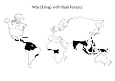
World Map With Rain Forests
In this geography worksheet, young scholars study a map of the world which shows shaded areas indicating where the rain forests are located. There are no labels for countries or continents.
Curated OER
Geography Puzzles
Students study the continents of the world. In this Internet geography lesson plan, students connect to online mapping games. Students collaborate in order to develop their understanding of world geography, including countries and...
Curated OER
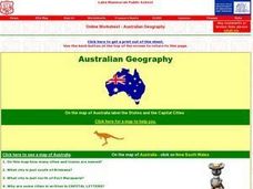
Australian Geography
In this map reading worksheet, students label a map of Australia by adding the names of states and cities. They answer eight questions about the map.
Curated OER
United States Map- Map Legend/City Symbols
Students investigate the United States map. In this map skills geography lesson, students explore city symbols on the map legend and identify them. Students use post-it notes to mark various symbols.
Curated OER
Maps
Maps, globes, and computer software aid young explorers as they locate state capitols, major cities, geographic features, and attractions for states they are researching. They then use desktop publishing software to create a map to share...
Curated OER
Map of Town
Third graders draw a map of the town given different sites to locate on the map by the teacher. They explain that latitude and longitude are used to locate places on maps and globes, identify the distinctive physical and cultural...
NET Foundation for Television
1850-1874 Railroads and Settlement
Have you ever wondered how your town was placed where it is? Scholars research the impact the advancement of the railroad due to the passage of the Kansas-Nebraska Act had on the formation of civilization in the Great Plains. Map...
