Curated OER
Puerto Rican Migration Historical Fiction Story
Students investigate the experience of Puerto Rican immigrants to America. In this immigration lesson plan, students research the challenges that Puerto Rican immigrants faced and then write historical fiction selections that reflect...
Curated OER
Map Skills
Students examine the nations, battlefields, troop movement of the Germans through Belgium and the location of both fronts during World War I by creating a map. They visualize the strength of the Germans early in the war.
Curated OER
Paint My Counties: Map Coloring the Counties of Arizona
Fourth graders identify the counties of Arizona. For this social studies lesson, 4th graders color a county map of Arizona using the fewest number of colors possible. Students write a persuasive paragraph.
Curated OER
Kid Maps: Reading and Creating Maps with Human Characteristics
Students look at maps. For this map lesson, students listen to the book My Map Book by Sara Fanelli and they see the difference between human characteristics (buildings, etc.) and natural characteristics (rivers, etc.). They create...
Curated OER
In Our Time
Middle schoolers map the ideas, people, and beliefs of a period of history. They analyze influences of historical eras. Students use mapping as a prewriting strategy. They use Inspiration to map the key events, ideas, and...
Midwest Institute for Native American Studies
Introduction to Pre-Columbian Lessons
Native peoples established civilizations all over Central and North America. Introduce native civilizations with a unit that promotes discussion, reinforces map skills, enhances reading comprehension, and exposes young historians to the...
Curated OER
North Carolina Historical Sites
Eighth graders design and create a tourist brochure for North Carolina historical sites. They research North Carolina, find and scan pictures for their brochure, use ClarisWorks to form the text, print, display and use constructive...
Curated OER
The French Revolution
Starting with a quote by Charles Dickens from A Tale of Two Cities, the slides featured in this presentation go into thorough detail about the French Revolution. It includes portraits of key historical figures, maps, and demographic...
Curated OER
Putting It on the Map
Students consider the purpose of various types of maps and their different uses throughout history. They create their own maps and reflect on the map-making process.
Curated OER
Colonial Vacation Planner
Students plan a family vacation to states that were among the original 13 colonies. The groups determine which state they visit, map their route, calculate the mileage, and determine how much money they spend on gasoline.
Curated OER
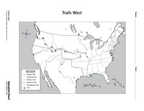
Trails West: Westward Expansion Maps
In this United States historical map worksheet, students examine the trails that settlers of the Western United States took during the period of Western Expansion. Major cities on the routes are labeled.
Curated OER
Trails West Map
In this United States historical map worksheet, students examine the trails that settlers of the Western United States took during the period of Western Expansion.
Curated OER
Solving the Puzzle
Students create a map showing the United States borders at a specific period in history and produce three questions to be answered by examining the map. They also write a productive paragraph explaining who, what, when, where, how/why a...
National Wildlife Federation
I Speak for the Polar Bears!
Climate change and weather extremes impact every species, but this instructional activity focuses on how these changes effect polar bears. After learning about the animal, scholars create maps of snow-ice coverage and examine the yearly...
Smithsonian Institution
A Ticket to Philly—In 1769: Thinking about Cities, Then and Now
While cities had only a small fraction of the population in colonial America, they played a significant role in pre-revolutionary years, and this was certainly true for the largest city in the North American colonies: Philadelphia. Your...
Curated OER
Mapping Roxaboxen
Fourth graders read Roxaboxen and draw a map of the Roxaboxen community. In this language arts and geography lesson, 4th graders use specifications given, adding features to the map as described in the book and creating a legend.
Curated OER
Introduction of the Lunar Relief Map Project
Students investigate the geographic features of the surface of the moon. In this lunar relief map lesson, students watch and discuss the Apollo II Moon landing and make preliminary plans for their lunar maps.
Curated OER
What Are Maps For?
Young scholars create a story about a problem someone could have which could be solved by the use of a map. They complete a worksheet that guides them through the features of a map of Chicago. Then they calculate story problems using...
Curated OER
Creating a 3d Model and Corresponding Topographic Map
Students create a landform model and topographic map. In this topography lesson, students use a real landform to create a model and topographic map to scale.
Curated OER
Historical Heroes and Character Sketches
Learners write a character sketch and present it in first person. In this historical heroes and character sketches activity, students "meet" Harriet Tubman (played by their teacher) and discuss her contributions. Learners read examples...
Curated OER
Planning A Railroad
Students use topographical maps students explain the challenges involved in building the railroad in the Sierra Nevada mountains.
Curated OER
Life in Old Babylonia: The Importance of Trade
Students read maps and artifacts for information indicating the existence of a trade network in Old Babylonia and beyond. They list goods imported to and exported from Babylonia. They indicate trading centers on a map of ancient...
Curated OER
About Life: The Photographs of Dorothea Lange Going to the Promised Land
To better understand the migrant experience during the Great Depression, pupils analyze two primary resources: photographs by Dorothea Lange and a U.S. Map that shows the Dust Bowl. They compare and contrast Lange's images to Steinbeck's...
Museum of Tolerance
Where Do Our Families Come From?
After a grand conversation about immigration to the United States, scholars interview a family member to learn about their journey to America. They then take their new-found knowledge and apply their findings to tracking their family...


