National Endowment for the Humanities
Lesson 1: On the Road with Marco Polo: A Boy in 13th Century Venice
Learners investigate Marco Polo's life as a young boy in 13th century Venice. They analyze maps, explore various websites, complete a chart and answer discussion questions, and create a travel brochure about visiting 13th century Venice.
Curated OER
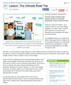
The Ultimate Road Trip
Sixth graders experience and practice real-world geography, science and math as they imagine planning out the ultimate road trip. They set goals and maintain a daily budget as they are given a set of rules as they plan their road trip...
Little 10 Robot
Geography Drive USA™
A trivia-style virtual road trip in which the player's car is moved from state to state as questions are correctly answered. Ideally, a player would learn about different states by reading the simple brochures available in the...
Curated OER
Denali Park Topographic Maps
Students construct a topographic map of the Denali National Park. They identify different elevations and record historic landmarks in student science journals.
Curated OER
Map the Civil War
Students explore the Civil War through original maps. In this mapping lesson, students calculate distance and show it on an original map. Students examine the type of landscape and its landmarks and draw symbols on the map.
Curated OER
Kinds of Maps
In this map instructional activity, students match a set of descriptions with the names of different types of maps and answer true/false questions and short answer questions about using maps.
Statistics Education Web
What Percent of the Continental US is Within One Mile of a Road?
There are places in the US where a road cannot be found for miles! The lesson asks learners to use random longitude and latitude coordinates within the US to collect data. They then determine the sample proportion and confidence interval...
Concord Consortium
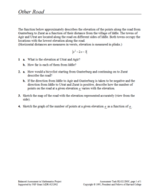
Other Road
Take the road to a greater knowledge of functions. Young mathematicians graph an absolute value function representing a road connecting several towns. Given a description, they identify the locations of the towns on the graph.
Concord Consortium
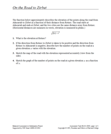
On the Road to Zirbet
The road to a greater knowledge of functions lies in the informative resource. Young mathematicians first graph a square root function in a short performance task. They then use given descriptions of towns and the key features of the...
Curated OER
On the Road with Marco Polo: Marco Polo in China
Learners investigate who the Mongols were and where their empire was located. They research Kublai Khan and the region he ruled. They study the major products of 13th Century China.
Curated OER
Introducing Topographic Maps: Guiding Students from Concrete Models to Graphic Representations
Young scholars interpret topographic maps and infer human activity as it is influenced by the landscape.
Curated OER
Post Roads
Students locate the major cities in the colonies during the Revolutionary War. For this map skills lesson, students use a globe to locate cities such as Charleston and Boston using latitude and longitude coordinates.
Curated OER
Map Skills
For this map worksheet, students use a map and key to complete a set of 7 questions. Answers are included on page 2, questions focus on miles and direction.
Curated OER
Treasures Along the Silk Roads
Ninth graders examine the travels of the Silk road. In this Ancient China lesson, 9th graders analyze slides of artifacts as cultural and social representations of the Silk Road civilizations. Students create a word map and creative...
Curated OER
Map Reading in the 21st Century
Students interact with MapPoint tools to view maps of the past and the present in multiple ways. They participate in mini-lessons aimed at locating certain points of interest or famous routes taken in history.
Curated OER
Ease on Down the Road
For this math quantities worksheet, students utilize a variety of strategies to strengthen their concepts between two quantities while experiencing family road trips. Students calculate miles per hour, cost of gasoline per gallon,...
Curated OER
Westward Expansion : Mapping
Fifth graders travel along exploring the expeditions of John F. Fremont. For this Westward expansion lesson, 5th graders gain understanding of the events that shaped the west through the use of maps. Students use mapping skills to...
Curated OER
Planning a Road Trip!
Learners generate plans for a fictitious road trip. For this time management lesson, students investigate the most effective way to travel the country arriving at specific cities. Learners create their plans based on time and distance.
Curated OER
Mapping School Grounds
Students map and analyze the natural and cultural environment of the school grounds. In small groups, they sketch the natural and cultural features of each side of the school building, create a map, participate in a class discussion,...
Curated OER
Topographic Maps
In this topographic map worksheet, students learn how to read a topographic map and create a topographic map of their own using clay or Play-Doh. Students include contour lines by layering the clay. Students answer 6 questions about...
Curated OER
Scaling in Maps
In this recognizing map scale ratios worksheet, students use ratios and centimeter measurements to calculate the distances in reality. Students solve 8 problems.
Curated OER
Organization of a Territory, Map Elements
Third graders compare printed and online maps and use proper geographic terminology to answer questions.
Curated OER
What Do Maps Show?
Students discover the uses for various types of maps. In this geography skills lesson, students discuss the type of maps that exist and what their individual features are. Students then practice using different types of maps.
Curated OER
Introduction to Maps
Students develop their map skills. In this geography lesson, students participate in an activity that requires them to survey their social studies book in order to find different types of maps and purposes for their uses.
Other popular searches
- Road Map Activities
- Reading Road Maps
- Missouri Road Maps
- Reading Road Map Strategy
- Math Reading Road Map
- Road Map Directions
- Using a Road Map
- Civil War Road Map
- Silk Road Maps
- Create a Road Map
- Road Map Lesson
- Middle East Road Map


